Behind the Headlines – World Book Student
  • Search

  • Archived Stories

    • Ancient People
    • Animals
    • Arts & Entertainment
    • Business & Industry
    • Civil rights
    • Conservation
    • Crime
    • Current Events
    • Current Events Game
    • Disasters
    • Economics
    • Education
    • Energy
    • Environment
    • Food
    • Government & Politics
    • Health
    • History
    • Holidays/Celebrations
    • Law
    • Lesson Plans
    • Literature
    • Medicine
    • Military
    • Military Conflict
    • Natural Disasters
    • People
    • Plants
    • Prehistoric Animals & Plants
    • Race Relations
    • Recreation & Sports
    • Religion
    • Science
    • Space
    • Technology
    • Terrorism
    • Weather
    • Women
    • Working Conditions
  • Archives by Date

Posts Tagged ‘indian ocean’

Deadly Storm Floods South Africa

Tuesday, April 19th, 2022
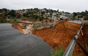
As a result of April 2022 flooding, a river burst its banks and destroyed a bridge in Durban, South Africa.  Credit: © Rogan War, Reuters/Alamy Images

As a result of April 2022 flooding, a river burst its banks and destroyed a bridge in Durban, South Africa.
Credit: © Rogan War, Reuters/Alamy Images

Several days of heavy rain have caused severe flooding and mudslides on the east coast of South Africa. A new storm came off the Indian Ocean on Tuesday, April 12th, destroying bridges, roads, houses, and other structures. The storm hit the city of Durban, South Africa’s chief seaport and one of its largest cities, killing at least 443 people. Officials report that 63 people remain missing amidst the damage in the province of KwaZulu-Natal.

The influx of rain is a result of a weather phenomenon called a cut-off low, which occurs when a low-pressure system is disrupted and moves slowly across an area. The storm produced the heaviest rains in South Africa in 60 years and is the deadliest storm on record in the country. Meteorologists estimate that over a month’s worth of rain, nearly 12 inches (30.5 centimeters), fell in one day in Durban.

The downpour of rain caused mudslides that washed away entire hillsides, destroying nearly 600 schools and  60 health facilities. More than 12,000 homes have been damaged from the flooding and mudslides. Some schools were in session during the storm, trapping students and teachers inside. Many people sought higher ground and climbed on top of roofs to stay out of reach of the rushing water and mud.

The flooding also washed out complete roads and bridges. One bridge outside Durban collapsed, leaving people stranded on both sides. The rushing water knocked out all power in the area. The mudslides and damage cut off the supply of clean water. Stacks of shipping containers have collapsed into the water.

Rescue efforts continue to find missing people believed to be underneath houses affected by the mudslides. South African President Cyril Ramaphosa visited with people affected by the disaster and pledged to help rebuild the community.

Tags: destruction, durban, flood, indian ocean, mudslide, rain, seaport, south africa, storm
Posted in Current Events, Disasters | Comments Off

Exploring the Five Deeps

Friday, September 27th, 2019

September 27, 2019

Last month, on August 24, the American undersea explorer Victor Vescovo reached the Molloy Deep (also known as the Molloy Hole), the deepest point—some 3.4 miles (5.5 kilometers) beneath the surface—of the Arctic Ocean. Upon completion of the dive, Vescovo became the first person to dive to the deepest parts of all five of the world’s oceans. Over the previous 10 months, Vescovo’s Five Deeps Expedition had reached the ultimate bottoms of the Atlantic, Southern, Indian, and Pacific oceans.

Victor Vescovo indicates to he Expedition Team the proposed routing for the South Sandwich. Credit: © The Five Deeps Expedition

American explorer Victor Vescovo and the Five Deeps team discuss the South Sandwich Trench near Antarctica on Feb. 3, 2019. Credit: © The Five Deeps Expedition

Victor Vescovo was born in Dallas, Texas, in 1966. He developed a love of the ocean as a 20-year officer in the United States Navy Reserve. At the same time, he made a fortune as a private businessman. Vescovo’s taste for adventure pushed him to climb the highest peaks on each of the world’s continents—including Asia’s Mount Everest, the tallest mountain in the world. He has also skied to the North and South poles and is an airplane and helicopter pilot.

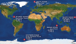
Click to view larger image Map of the five expeditions. Credit: WORLD BOOK illustration by Brenda Tropinski; © Best Backgrounds/Shutterstock

Click to view larger image
The Five Deeps Expedition reached the five deepest points of the world’s oceans. Credit: WORLD BOOK illustration by Brenda Tropinski; © Best Backgrounds/Shutterstock

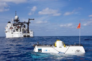
Having conquered the world’s summits, Vescovo planned the Five Deeps Expedition to explore its depths. Vescovo and his company Caladan Oceanic put together a team of engineers, scientists, and experienced sea personnel. Caladan’s specially designed submersible, Limiting Factor, made the deep dives, supported by the surface vessel Pressure Drop. A submersible is an undersea vessel used for oceanographic research and exploration.

The mother ship "DSSV Pressure Drop" (background) and the dive boat "DSV Limiting Factor" during the expedition in the Indian Ocean. Credit: © The Five Deeps Expedition

On April 2, 2019, the Five Deeps submersible Limiting Factor rests on the surface of the Indian Ocean behind the support ship Pressure Drop. Credit: © The Five Deeps Expedition

Five Deeps began in December 2018 at the Bronson Deep in the Puerto Rico Trench, the deepest point of the Atlantic Ocean. (A deep is an ocean area with a depth of more than 18,000 feet [5,490 meters]). Vescovo set an Atlantic record by diving alone in Limiting Factor to a depth of 27,480 feet (8,376 meters). (Mount Everest goes 29,035 feet [8,850 meters] in the other direction.) Two months later, in February 2019, Vescovo and his team took Pressure Drop near the coast of Antarctica above the South Sandwich Trench in the Southern Ocean. Vescovo then set a Southern Ocean record by diving solo to a depth of 24,390 feet (7,434 meters). (Determining exact depths can be tricky, but after the Five Deeps numbers are verified, they will slightly redefine the landscape of the world’s ocean bottoms.)

In April, Five Deeps headed to the Indian Ocean and the Java Trench (also called the Sunda Trench) near the Indonesian island of Sumatra. Vescovo took Limiting Factor to a depth of 23,596 feet (7,192 meters) in the Indian Ocean, and captured film of a new species of hadal snailfish (a type of sea snail) and other deep bottom-dwelling creatures. The crew then took Pressure Drop above Challenger Deep in the Mariana Trench, an underwater depression in the Pacific Ocean that is the deepest known spot in the world. There, in May, Vescovo set a record for the deepest ever dive, reaching 35,853 feet (10,927 meters) into Challenger Deep’s eastern pool. The previous depth record was set at Challenger Deep in 1960 by the U.S. Navy Lieutenant Don Walsh and the Swiss oceanographer Jacques Piccard, who dived 35,797 feet (10,911 meters) beneath the ocean surface in the bathyscaph (a special diving craft) Trieste. Vescovo discovered three new species of marine animals on his voyage to the bottom of Challenger Deep—along with pieces of plastic trash and other signs of pollution.

In 1960, Swiss explorer Jacques Piccard (center) descended into the Mariana Trench deep in the Pacific Ocean with Lieutenant Don Walsh (front) of the United States Navy in the Trieste, a deep-sea diving ship designed by Piccard. Credit: Steve Nicklas, NOS/NGS

In 1960, Swiss explorer Jacques Piccard (center) descended into the Mariana Trench with Lieutenant Don Walsh (front) of the United States Navy. Credit: Steve Nicklas, NOS/NGS

The Five Deeps Expedition explored another Pacific deep point in June, diving 35,509 feet (10,823 meters) to the bottom of the Tonga Trench’s Horizon Deep. And then in early August, while traveling through the North Atlantic on the way to the Arctic, Five Deeps visited the watery grave of the ill-fated ocean liner Titanic, some 13,000 feet (4,000 meters) beneath the waves. A couple weeks later, the team reached the Molloy Trench off the coast of Norway, where Vescovo made the final dive. The Five Deeps Expedition, whose motto was In Profundo: Cognitio (Latin for In the Deeps: Knowledge), wrapped up in September.

The Five Deeps Expedition traveled more than 46,000 miles (74,000 kilometers), discovered several new species of marine animals, and mapped over 116,000 square miles (300,000 square kilometers) of sea floor. In addition to the piloted dives, the Five Deeps team deployed robotic deep-sea landers in several locations. The expedition also recorded over 500 hours of video that will be made into the Discovery Channel documentary series “Deep Planet,” scheduled to air in 2020.

Tags: arctic ocean, atlantic ocean, diving, five deeps expedition, indian ocean, jacques piccard, mariana trench, oceans, pacific ocean, sea exploration, southern ocean, submersible, victor vescovo
Posted in Conservation, Current Events, Environment, People, Science, Technology | Comments Off

Recovering from Cyclone Idai

Friday, April 26th, 2019

April 26, 2019

Last month, in March, Tropical Cyclone Idai struck the southeastern coast of Africa. One of the strongest storms ever recorded in the Southern Hemisphere, Idai caused catastrophic landslides and flooding that killed more than 1,000 people in Mozambique and in neighboring Malawi and Zimbabwe. The storm left more than 300,000 people homeless and led to deadly outbreaks of cholera and increased cases of malaria. More than a month later, thousands of people remain missing in affected areas, and government and international aid agencies continue to struggle to provide badly needed food, water, and medical supplies.

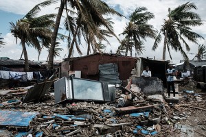
An owner (2nd R) stays at his destroyed bar after the cyclon Idai hit near the beach in Beira, Mozambique, on March 23, 2019. - The death toll in Mozambique on March 23, 2019 climbed to 417 after a cyclone pummelled swathes of the southern African country, flooding thousands of square kilometres, as the UN stepped up calls for more help for survivors. Cyclone Idai smashed into the coast of central Mozambique last week, unleashing hurricane-force winds and rains that flooded the hinterland and drenched eastern Zimbabwe leaving a trail of destruction. Credit: © Yasuyoshi Chiba, AFP/Getty Images

On March 23, 2019, residents of Beira, a coastal city in central Mozambique, survey the damage done by Cyclone Idai. Credit: © Yasuyoshi Chiba, AFP/Getty Images

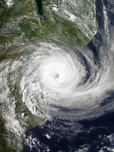
Cyclone Idai formed as a tropical depression over the warm waters of the southwestern Indian Ocean in early March. The storm intensified into a cyclone as it struck central Mozambique on March 4. Torrential rains and deadly winds whipped coastal areas for days as Idai spun along the Mozambique Channel between the African mainland and the island of Madagascar. Idai varied in strength, until reaching peak intensity with winds of 150 miles (240 kilometers) per hour on March 14. After 17 days of damage and deluge, the storm finally weakened and dissipated on March 21.

Intense Tropical Cyclone Idai approaching the Sofala province of Mozambique on 14 March 2019, shortly after reaching its peak intensity. Credit: NASA

This satellite image shows Cyclone Idai in the Mozambique Channel on March 14, 2019. Credit: NASA

The broad and determined storm reached inland to Malawi and Zimbabwe and pelted coastal areas of Madagascar. The storm extensively damaged or destroyed vital infrastructure, including communication networks, hospitals, roads, sanitation facilities, and schools. Wide swaths of farmland were ruined, portions of forests were flattened by high winds, and flooding created a temporary inland sea in Mozambique that measured some 80 miles (130 kilometers) long and 15 miles (24 kilometers) wide. Mozambique President Filipe Nyusi called Cyclone Idai a “humanitarian disaster of great proportion.”

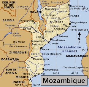
Click to view larger image Mozambique Credit: WORLD BOOK map

Mozambique. Credit: WORLD BOOK map

Mozambique’s typically able Instituto Nacional de Gestão de Calamidades (National Disasters Management Institute) was overwhelmed by the scale of Idai’s destruction, and an urgent note verbale (formal diplomatic notice) went out requesting international help. The Red Cross and Red Crescent, Doctors Without Borders, and several United Nations organizations came to the rescue, as did the European Union and the governments of Canada, France, Portugal, South Africa, and the United Kingdom.

Cyclone Idai was the seventh tropical cyclone of the Indian Ocean season, more than twice the average for this time of year. Globally, high-intensity storms have been occurring more frequently in recent years, a trend directly related to climate change. Global warming increases sea temperatures, creating more moisture and instability in the atmosphere—factors crucial to the birth of dangerous cyclones and hurricanes. Tropical cyclones need high humidity and surface water temperatures of 79 °F (26 °C ) or higher to form. Melting glaciers and ice have increased global sea levels, resulting in more frequent and intense flooding in coastal areas around the world.

Tags: africa, climate change, cyclone, cyclone idai, disasters, global warming, indian ocean, malawi, mozambique, zimbabwe
Posted in Current Events, Disasters, Environment, Health, Natural Disasters, People, Weather | Comments Off

First Evidence of Missing Flight 370 Found

Monday, August 10th, 2015

August 10, 2015

Aviation experts confirmed last week that a piece of an airplane wing that washed up on a beach at remote island in the Indian Ocean is from Malaysia Airlines Flight 370. The fragment represents the first physical evidence of the missing Boeing 777 aircraft yet found. The disappearance of Flight 370 more than one year ago has been one of the greatest unsolved mysteries of modern aviation.

Flight MH370 was flown in a Boeing 777-300, a large twin-engine passenger jet. The airliner can fly about a fourth of the way around the world without refueling. (The Boeing Company)

Flight MH370 was flown in a Boeing 777-300, a large twin-engine passenger jet. The airliner can fly about a fourth of the way around the world without refueling. (The Boeing Company)

The fragment, a six-foot (2 meter) portion of a wing flap, washed ashore on July 29 at a beach on Réunion, a remote volcanic island about 400 miles (640 kilometers) east of Madagascar. Investigators quickly determined that it came from a Boeing 777, the same kind of aircraft as Flight 370.

On March 8, 2014, Malaysia Airlines flight 370 took off from Malaysia’s capital, Kuala Lumpur on a flight to Beijing with 227 passengers and 12 crew members. About 2 hours into the routine flight, all contact with the aircraft was lost. The mysterious disappearance of the flight led to a massive international search effort. This, in turn, triggered a massive media frenzy with “experts” endlessly speculating on what might have gone wrong. Clues from satellite data showed the aircraft made a controlled turn mid-flight and it then flew along the southern corridor towards the middle of the Indian Ocean. Experts believe the airplane crashed in the ocean somewhere west of Perth, Australia. But no wreckage or other remains of the airplane or passengers has been found in more than a year.

A check of records of aircraft and replacement parts found that Flight 370 was the only plane of that model missing in the world. By the weekend, the fragment was flown to Toulouse, France, for closer inspection by aeronautical engineers at a test facility run by the French military. Aviation experts think that a close examination of the wing flap could provide clues about the moment when the plane hit the water. By examining how the wing flap broke off, they can tell the direction and attitude of the airplane when it hit the water. However, the sole fragment will not likely answer the question of exactly what went wrong on the ill-fated flight. Meanwhile, the search continues for more evidence that can finally solve the mystery of Flight 370.

Other World Book articles:

  • Aviation (2014) – A Back in Time article
  • Disasters (2014) – A Back in Time article
  • Flight MH370 Went Down in the Southern Indian Ocean, Analysts Conclude (March 24, 2014) – A Behind the Headlines article
  • Vessels Search for MH370 Detect Signals off Australia (April 7, 2014) – A Behind the Headlines article

Tags: aeronautics, boeing 777, indian ocean, malaysian airlines, plane crash
Posted in Current Events, Disasters | Comments Off

Vessels Search for MH370 Detect Signals off Australia

Monday, April 7th, 2014

April 7, 2014

An Australian ship searching for the missing Malaysia Airlines plane in the southern Indian Ocean yesterday detected signals consistent with those from “black box” flight recorders. Using a towed pinger locater, the crew of the Ocean Shield picked up the signal twice–once for 2 hours and 20 minute–about 1,040 miles (1,680 kilometers) northwest of Perth, Australia. The leader of the search team, Australian Air Chief Marshal Angus Houston, told the media “two distinct pinger returns were audible. Significantly this would be consistent with transmissions from both the flight data recorder and the cockpit voice recorder.” A Chinese vessel also detected signals on April 5 in the same general area. The southern Indian Ocean in that region is approximately 14,770  feet (4,500 meters) deep.

Flight MH370 was flown in a Boeing 777-300, a large twin-engine passenger jet. The airliner can fly about a fourth of the way around the world without refueling. (The Boeing Company)

Malaysia Airlines flight MH370, carrying 239 people, was en route from Kuala Lumpur to Beijing on March 8 when it disappeared, most likely in the southern Indian Ocean. Authorities describe the search operation as a race against time because the batteries operating the flight recorders are about to run out. “I believe they have got three to four more days of good, solid output,” the BBC quotes Chris Portale, the director of the American company that makes the device that emits signals from flight recorders.

Additional World Book article:

  • Turbulence: Hidden Threat in the Skies (a special report)

Tags: black box, flight recorders, indian ocean, malaysian airlines
Posted in Business & Industry, Current Events, Government & Politics, People, Science, Technology | Comments Off

Flight MH370 Went Down in the Southern Indian Ocean, Analysts Conclude

Monday, March 24th, 2014

March 24, 2014

Malaysia’s prime minister, Najib Razak, announced today that Malaysia Airlines flight MH370, which has been missing for two weeks, crashed into the southern Indian Ocean and sank without a trace. Razak stated that the British government’s Air Accidents Investigation Branch (AAIB) and Inmarsat, a private British company that provides satellite data, “have concluded that MH370 flew along the southern corridor, and that its last position was in the middle of the Indian Ocean, west of Perth [Australia].” “This is a remote location, far from any possible landing sites,” he noted. “It is therefore with deep sadness and regret that I must inform you that, according to this new data, flight MH370 ended in the southern Indian Ocean.” Before the announcement, the families of the people on board the fight were told that the British analysts had concluded “beyond reasonable doubt” that the plane was lost and that there were no survivors.

Flight MH370 was en route from Malaysia’s capital, Kuala Lumpur, to Beijing with 227 passengers and 12 crew members when it disappeared on March 8. The mysterious disappearance of the Boeing 777 led to a massive international search effort. This, in turn, triggered a massive media frenzy with “experts” endlessly speculating on what might have gone wrong.

Flight MH370 was flown in a Boeing 777-300, a large twin-engine passenger jet. The airliner can fly about a fourth of the way around the world without refueling. (The Boeing Company)

The day after the plane disappeared, Interpol revealed that two male passengers aboard the flight were traveling on passports stolen from an Austrian and an Italian in Thailand. This disclosure led to theories involving terrorism. Police discovered a flight simulator in the home of the pilot, from which files had recently been deleted. This led to speculation about his involvement. Just today, the chief executive of Malaysia Airlines, Ahmad Jauhari Yahya, revealed that MH370 carried several hundreds pounds of lithium batteries in the cargo hold. Such batteries can be a fire hazard under certain circumstances. He noted, however, that the batteries had been handled and packaged so that they were deemed “non-hazardous” under civil aviation standards.

While the Australian Navy continues to look for debris in the southern Indian Ocean, Flight MH370 remains the only commercial flight in history that seems to have disappeared without a trace.

Additional World Book articles:

  • Airplane
  • Turbulence: Hidden Threat in the Skies (a special report)

Tags: indian ocean, malaysian airlines
Posted in Business & Industry, Current Events, Economics, Energy, Government & Politics, Law, Military, Natural Disasters, People, Science, Technology, Weather | Comments Off

Breaking Plates: New Boundary in Indian Ocean

Thursday, October 18th, 2012

October 18, 2012

Two powerful earthquakes that jolted the floor of the Indian Ocean off the Indonesian island of Sumatra in April 2012 have given scientists an unprecedented opportunity to study a tectonic plate being torn in two. Tectonic plates are vast, irregularly shaped sections of Earth’s rocky outer shell that are in contant motion with respect to one another. In three analyses, international teams of scientists have described how the magnitude 8.6 and 8.2 quakes advanced a multimillion-year split in the Indian-Australian Plate and the birth of a new tectonic boundary. The Indian-Australian Plate includes the countries of Australia and India and the Indian Ocean.

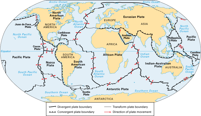
Earth’s rocky outer shell consists of huge slabs called tectonic plates. Many plates include both ocean floor and dry land. The plates slowly move with respect to one another. They spread apart at divergent boundaries, move toward each other at convergent boundaries, and grind past one another at transform boundaries. (World Book map)

The scientists reported that the magnitude 8.6 earthquake opened at least four major seafloor faults (cracks in Earth’s surface) running for several hundred miles (kilometers) in only 2 minutes and 40 seconds. The sides of these faults slipped between 20 to 120 feet (6 to 37 meters) past each other. In some cases, the earthquake turned corners, creating a bizarre gridlike pattern of cracks in the seafloor. The scientists also discovered that a highly unusual number of aftershocks of magnitude 5 or above occurred in the six days following the quakes. Some were felt as far away as the western coast of North America.

Information from a global network of seismographs had told scientists almost immediately that the magnitude 8.6 quake, which occurred about two hours before the 8.2 quake, was the most powerful strike-slip quake ever recorded. During a strike-slip earthquake, blocks of rock slide past each other horizontally. The Sumatra temblors were also highly unusual because they occurred in the middle of a plate. Strike-slip quakes generally occur at the boundary between two plates, such as along the San Andreas Fault in California.

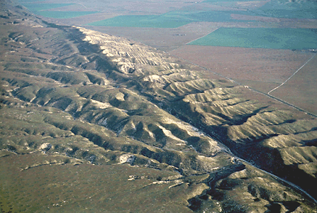
The San Andreas Fault, like the newly created faults in the Indian Ocean, is a strike-slip fault, a surface fracture where two blocks of rock are sliding past one another horizontally. (© Craig Aurness, Corbis)

The Indian-Australian Plate is breaking up because of tensions between its eastern and western sections. The eastern section, which includes India, is being thrust under the Eurasian Plate to the north. This action, which began tens of millions of years ago, pushed up the Himalaya. Meanwhile, the plate’s western section, which includes Australia, has continued to move to the northeast. From time to time, the tensions cause parts of the plate to suddenly slip past one another.

Two previous earthquakes in the area–a 2004 quake that produced a devastating tsunami in the Indian Ocean and another in 2005–probably put additional stress on the area of the plate that ruptured in April, the scientists reported. The recent quakes did not produce a tsunami because the sideways motion of a strike-slip quake does not cause the up-and-down movement of ocean water that powers the deadly waves. The scientists noted that the final breakup of the plate will occur only after millions of years and several thousand more earthquakes.

Additional World Book articles:

  • Haitian earthquake of 2010
  • When the Earth Moves (a Special Report)
  • Geology (2005) (a Back in Time article)


Tags: earthquake, geology, indian ocean, plate boundary, plate tectonics, seismograph
Posted in Current Events, Natural Disasters, Science | Comments Off

Major Quakes Shake Sumatra

Wednesday, April 11th, 2012

April 11, 2012

Indonesia’s Aceh province was shaken this morning by two major earthquakes–one with a magnitude of 8.6, the other measuring 8.3. The earthquakes were centered below the Indian Ocean at a depth of 20 miles (33 kilometers), some 300 miles (495 kilometers) off the coast of Banda Aceh, the provincial capital. Fearing a tsunami like the disastrous one in 2004, the Pacific Tsunami Warning Center issued a tsunami warning. The warning was cancelled after no massive waves developed from the quake. The Indian Ocean tsunami of 2004 killed some 250,000 people in coastal areas of Southeast Asia, South Asia, and East Africa.

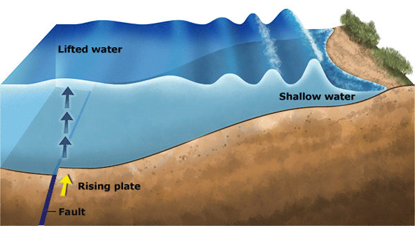
An earthquake under the ocean may cause a tsunami, a series of ocean waves that can cause tremendous destruction along coastlines. (World Book illustration by Matt Carrington)

Indonesia is regularly struck by earthquakes. The country’s island of Sumatra is close to an active subduction zone, where the Indian-Australian tectonic plate presses into and under the Eurasian plate. The collision of the plates has created a huge depression on the ocean floor known as the Sunda Trench. Strain between the plates at this depression is eventually released in the form of an earthquake.


Additional World Book articles

  • Big Waves: Tracking Deadly Tsunamis (a special report)
  • When the Earth Moves (a special report)
  • Indonesia 2004 (Back in Time article)
  • Indonesia 2005 (Back in Time article)

Tags: earthquake, indian ocean, indonesia, plate tectonics, sumatra, tsunami
Posted in Current Events, Natural Disasters, Science | Comments Off

  • Most Popular Tags

    african americans ancient greece archaeology art australia barack obama baseball bashar al-assad basketball black history month china climate change conservation earthquake european union football france global warming iraq isis japan language monday literature major league baseball mars mexico monster monday mythic monday mythology nasa new york city nobel prize presidential election russia space space exploration syria syrian civil war Terrorism ukraine united kingdom united states vladimir putin women's history month world war ii