Behind the Headlines – World Book Student
  • Search

  • Archived Stories

    • Ancient People
    • Animals
    • Arts & Entertainment
    • Business & Industry
    • Civil rights
    • Conservation
    • Crime
    • Current Events
    • Current Events Game
    • Disasters
    • Economics
    • Education
    • Energy
    • Environment
    • Food
    • Government & Politics
    • Health
    • History
    • Holidays/Celebrations
    • Law
    • Lesson Plans
    • Literature
    • Medicine
    • Military
    • Military Conflict
    • Natural Disasters
    • People
    • Plants
    • Prehistoric Animals & Plants
    • Race Relations
    • Recreation & Sports
    • Religion
    • Science
    • Space
    • Technology
    • Terrorism
    • Weather
    • Women
    • Working Conditions
  • Archives by Date

Posts Tagged ‘storm’

Deadly Storm Floods South Africa

Tuesday, April 19th, 2022
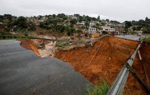
As a result of April 2022 flooding, a river burst its banks and destroyed a bridge in Durban, South Africa.  Credit: © Rogan War, Reuters/Alamy Images

As a result of April 2022 flooding, a river burst its banks and destroyed a bridge in Durban, South Africa.
Credit: © Rogan War, Reuters/Alamy Images

Several days of heavy rain have caused severe flooding and mudslides on the east coast of South Africa. A new storm came off the Indian Ocean on Tuesday, April 12th, destroying bridges, roads, houses, and other structures. The storm hit the city of Durban, South Africa’s chief seaport and one of its largest cities, killing at least 443 people. Officials report that 63 people remain missing amidst the damage in the province of KwaZulu-Natal.

The influx of rain is a result of a weather phenomenon called a cut-off low, which occurs when a low-pressure system is disrupted and moves slowly across an area. The storm produced the heaviest rains in South Africa in 60 years and is the deadliest storm on record in the country. Meteorologists estimate that over a month’s worth of rain, nearly 12 inches (30.5 centimeters), fell in one day in Durban.

The downpour of rain caused mudslides that washed away entire hillsides, destroying nearly 600 schools and  60 health facilities. More than 12,000 homes have been damaged from the flooding and mudslides. Some schools were in session during the storm, trapping students and teachers inside. Many people sought higher ground and climbed on top of roofs to stay out of reach of the rushing water and mud.

The flooding also washed out complete roads and bridges. One bridge outside Durban collapsed, leaving people stranded on both sides. The rushing water knocked out all power in the area. The mudslides and damage cut off the supply of clean water. Stacks of shipping containers have collapsed into the water.

Rescue efforts continue to find missing people believed to be underneath houses affected by the mudslides. South African President Cyril Ramaphosa visited with people affected by the disaster and pledged to help rebuild the community.

Tags: destruction, durban, flood, indian ocean, mudslide, rain, seaport, south africa, storm
Posted in Current Events, Disasters | Comments Off

Dorian’s Destruction in the Bahamas

Monday, September 23rd, 2019

September 23, 2019

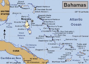
Three weeks ago, on September 1, Hurricane Dorian savaged the Bahamas, a chain of islands east of Florida in the Atlantic Ocean. In the slang of the islands, Dorian mashed up (devastated) much of Grand Bahama and the Abaco Islands in the northwestern part of the archipelago. Dorian, one of the strongest hurricanes on record to strike the Bahamas, killed at least 53 people there. That number will almost certainly skyrocket, however, as more than 600 people remain missing.

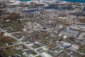
An aerial view of floods and damages from Hurricane Dorian on Freeport, Grand Bahama on September 5, 2019.  Credit: © Adam DelGiudice, AFP/Getty Images

Hurricane Dorian’s high winds and floods destroyed much of Freeport, Grand Bahama, seen here on Sept. 5, 2019. Credit: © Adam DelGiudice, AFP/Getty Images

Dorian struck the Bahamas as a category 5 storm on the Saffir-simpson scale, which measures hurricane intensity. Category 5 is the strongest hurricane rating, with winds above 157 miles (252 kilometers) per hour. Hurricanes of this strength typically occur about every three years, but Dorian marked the fourth consecutive year that a category 5 hurricane has struck the Caribbean, with two striking in 2017 when Irma and Maria killed more than 3,000 people, mostly in Puerto Rico. Hurricanes of all categories can cause terrible destruction and loss of life, but category 5 hurricanes are labeled “catastrophic” by the United States National Oceanic and Atmospheric Administration (NOAA). Winds that strong will destroy most framed houses by tearing away roofs and collapsing walls. They will flatten trees and electric power poles and leave residential areas uninhabitable for weeks or months. Increases in the intensity of hurricanes and other bad weather align with what scientists expect as the world’s climate continues to change.

Click to view larger image Bahamas.  Credit: WORLD BOOK map

Click to view larger image
Bahamas.
Credit: WORLD BOOK map

Dorian formed as a tropical depression over the Atlantic Ocean on August 24. A tropical depression is a low-pressure area surrounded by winds that have begun to blow in a circular pattern. Dorian developed into a hurricane four days later. The storm rapidly gained size and strength, reaching category 5 status by September 1. That day, the massive hurricane hit Elbow Cay and Great Abaco Island before moving on to Grand Bahama, where Dorian lingered for more than 24 devastating hours. Dorian lashed the islands with sustained winds of 185 miles (300 kilometers) per hour and gusts over 220 miles (350 kilometers) per hour. Storm surges (sudden onrushes of seawater) and torrential rains caused deadly flooding in many parts of the low-lying islands.

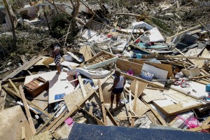
Two women look for lost items after Hurricane Dorian passed through in The Mudd area of Marsh Harbour on September 5, 2019 in Great Abaco Island, Bahamas. Hurricane Dorian hit the island chain as a category 5 storm battering them for two days before moving north.  Credit: © Jose Jimenez, Getty Images

On Sept. 5, 2019, people search through the ruins of their home in Marsh Harbour, Great Abaco Island, days after Hurricane Dorian hit as a category 5 storm. Credit: © Jose Jimenez, Getty Images

Dorian then spun away along the coasts of eastern Florida, Georgia, and South Carolina, greatly diminishing to a category 1—but still dangerous—hurricane before hitting Cape Hatteras in North Carolina’s Outer Banks on September 6. From there, Dorian further downgraded to an extratropical cyclone (a stormy low pressure system) and raced northward off the U.S. east coast. On September 7, Dorian’s final gasp brought heavy rains and fierce winds to Newfoundland and Nova Scotia in Canada. The storm at last dissipated near Greenland on September 10.

Dorian threatened many areas, and states of emergency were declared in several Caribbean and Atlantic islands and eastern U.S. states. But the storm’s rapid degradation after striking the Bahamas greatly reduced its deadliness. Dorian still killed people—directly or indirectly—outside the Bahamas, however, including one person in Puerto Rico, six people in Florida, and three people in North Carolina. Direct deaths are caused by such things as blown debris, flooding, or falling trees. Indirect deaths include people who die by accident or heart attacks while involved in storm-related activities, such as clearing trees or boarding up houses. They also include those who die in car accidents trying to evacuate.


Tags: bahamas, disaster, hurricane, hurricane dorian, storm
Posted in Current Events, Disasters, Environment, Natural Disasters, People, Science, Weather | Comments Off

The Wrath of Hurricane Matthew

Tuesday, October 11th, 2016

October 11, 2016

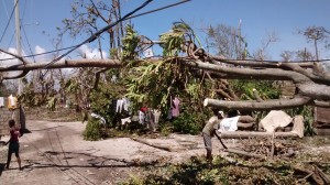
On Oct. 7, 2016, people in Les Cayes, Haiti, search through the wreckage left by Hurricane Matthew days earlier. Credit: Julien Mulliez, UK Department for International Development (licensed under CC BY 2.0)

On Oct. 7, 2016, people in Les Cayes, Haiti, search through the wreckage left by Hurricane Matthew days earlier. Credit: Julien Mulliez, UK Department for International Development (licensed under CC BY 2.0)

This past weekend, Hurricane Matthew ravaged the southeast Atlantic coast of the United States, causing flooding and accidents that killed at least 33 people in Florida, Georgia, South Carolina, North Carolina, and Virginia. The storm then weakened and turned out to sea, but flooding from heavy rains and storm surges continued in a number of areas. Matthew’s worst destruction, however, came days earlier when the hurricane made landfall in Haiti. There, the storm killed around 1,000 people and triggered a number of cholera cases. Deaths were also reported at sea and in the Dominican Republic, which shares the island of Hispaniola with Haiti.

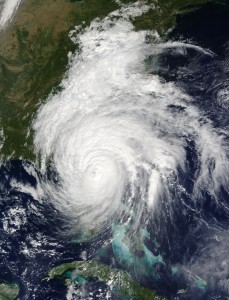
This is a visible image of Major Hurricane Matthew taken from NASA's Terra satellite on Oct. 7 at 12 p.m. EDT as it continued moving along Florida's East Coast. Matthew was a Category 3 hurricane at the time of this image. Credit: NASA's Goddard MODIS Rapid Response Team

A NASA satellite captured this image of Hurricane Matthew along the coast of Florida on Oct. 7, 2016. Credit: NASA’s Goddard MODIS Rapid Response Team

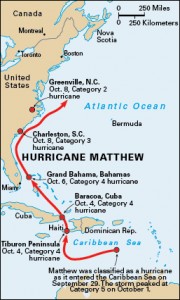
Hurricane Matthew formed as a tropical storm off the west coast of Africa in late September. The system strengthened as it prowled across the Atlantic Ocean, building into a hurricane as it entered the eastern Caribbean Sea. Peaking in strength at Category 5—the strongest hurricane rating with winds above 150 miles per hour (240 kilometers per hour)—Matthew scudded northwest and crashed into Haiti on October 4, devastating the country’s southwestern Tiburon Peninsula. Entire villages and farms were flattened or washed away, with contaminated water causing outbreaks of cholera. That same day, the storm lashed the eastern tip of Cuba, causing severe flooding in and around the city of Baracoa. Over the next two days, the storm rumbled over the Bahamas, doing its worst on Grand Bahama island just off the coast of Florida.

The storm path of Hurricane Matthew. Credit: WORLD BOOK map

Hurricane Matthew rolled through the Caribbean Sea and up the southeast coast of the United States in early October 2016. Credit: WORLD BOOK map

Hurricane Matthew then skirted the southeast coast of the United States, where mass evacuations had cleared many people from harm’s way. From October 7 through October 9, the storm caused flooding from Saint Augustine, Florida, up to Fort Pulaski, Georgia; Charleston, South Carolina; and inland into North Carolina and Virginia. Savannah, Georgia, recorded the highest rain total during the storm—more than 17 inches (44 centimeters). Around Greenville, North Carolina, flooding washed out highways and bridges, stranded motorists, and forced people to the roofs of their homes. In that state, boat and aircrews rescued more than 1,000 people—700 in central Cumberland County alone. Evacuations of coastal areas were fairly successful, but inland areas were often caught off guard. The storm also knocked out electric power for more than 2 million people and forced the closures of thousands of business and schools—including the Walt Disney World Resort in Orlando, Florida, which closed for just the fourth time in its history.

Tags: caribbean sea, haiti, hurricane, hurricane matthew, natural disaster, storm
Posted in Current Events, Disasters, Natural Disasters, People | Comments Off

Massive Storms Slam California

Friday, December 12th, 2014

December 12, 2014

After more than two years of extreme drought, California has been hit by the most powerful storm to cross the state in at least a decade.  A weather system known as a “pineapple express” hammered the north and center of the state with hurricane-force winds and up to 10 inches (25 centimeters) of rain yesterday. (A “pineapple express” is characterized by “an atmospheric river”–a strong and persistent flow of atmospheric moisture–that extends from the waters adjacent to the Hawaiian Islands to the Pacific Coast of North America.)

The storm left more than 220,000 people in northern California without electric power today after heavy rains and high winds slammed the region yesterday. For several hours, San Francisco received more than 1 inch (2.5 centimeters) of rain per hour. Some 240 flights were cancelled at the San Francisco airport, and flooding shut down the city’s Bay Area Rapid Transit system in some areas. The San Francisco Bay Ferry company was forced to cancel all ferry trips across the bay due to the foul weather. The National Weather Service in Sacramento yesterday issued a rare blizzard warning for higher elevations in northern California, and wind gusts in the Sierra Nevada mountains topped 140 miles (225 kilometers) per hour.

A Pineapple Express (circled in red)—basically a river in the atmosphere—dumps huge amounts of rain on California in a short time. During this meteorological event, southwest winds bring warm, moist air to the U.S. West Coast. (National Climate Data Center at the National Oceanic and Atmospheric Administration)

The fast-moving storm is currently pounding southern California, leaving some 70,000 people across the region without electric power and triggering rockslides and mud flows. In some areas of the Los Angeles metropolitan area, rain was falling at a rate of 2 inches (5 centimeters) per hour.

Additional World Book articles:

  • Climate
  • How the Ocean Affects Climate (a special report)
  • Weather Terms—Cloudy or Clear? (a special report)


Tags: california, drought, storm
Posted in Current Events, Economics, Energy, Environment, Natural Disasters, Weather | Comments Off

Nebraska Hit By Twin Twisters

Tuesday, June 17th, 2014

June 17, 2014

A deadly double tornado struck Nebraska yesterday, causing 2 deaths and leaving at least 16 people injured. The two tornadoes touched down at the same time and traveled with about a mile (1.6 kilometers) between them. The small farming community of Pilger, Nebraska, about 60 miles (97 kilometers) southwest of Sioux City, Iowa, sustained heavy damage from the twisters. Monday’s storm system also brought damaging winds and rains to other Midwestern States, including Iowa, Minnesota, South Dakota, and Wisconsin. One area of South Dakota received more than a half-inch (1.27 centimeters) of rain in fewer than 3 minutes, flooding roads and interstates.

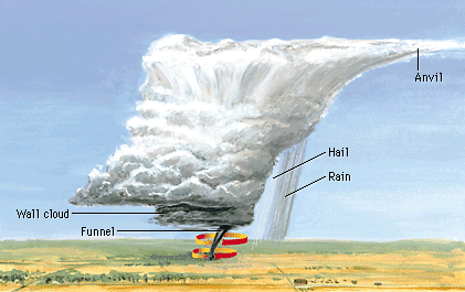
In addition to bringing high winds and rains, large, powerful thunderstorms can form deadly tornadoes. Such storms are called supercells. A supercell contains a rapidly rotating column of air called a mesocyclone. A smaller, swiftly rotating column of air called a funnel cloud can develop within the mesocyclone. If the funnel cloud reaches the ground, it becomes a tornado.

A tornado is a rapidly rotating column of air that can develop under a large, anvil-shaped thundercloud. Almost all tornadoes in the Northern Hemisphere rotate as shown in the diagram—counterclockwise when viewed from above (World Book illustration by Bruce Kerr).

Weather experts state that it is not uncommon for more than one tornado to form from a supercell. Usually, however, the first tornado shrinks and disappears as the second forms. Or, when two twisters form and both remain, there is usually one large, strong tornado and one smaller tornado. It is less common for the primary twister to keep going strong when a new twister forms, producing two tornadoes of the same strength at the same time. Nevertheless, that is what hit Nebraska Monday evening.


Additional World Book articles:

  • Tornado Alley
  • Twisted: More Terrible Tornadoes (a Special Report)

Tags: nebraska, storm, supercell, tornado
Posted in Current Events, Natural Disasters, Weather | Comments Off

Tornado Devastates Oklahoma City Suburb

Tuesday, May 21st, 2013

May 21, 2013

A tornado tore through Moore, Oklahoma, yesterday, a suburb of Oklahoma City, leaving 24 people dead, including 10 children.  The death count had been revised downward from the 51 dead initially reported. The medical examiners office believes some victims were counted twice in the early aftermath of the disaster.

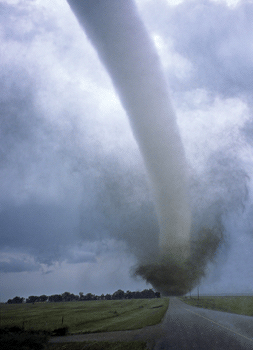
Tornados are created when certain conditions are met: adequate moisture in the air; a layer of warm, moist air near the ground and a layer of cool air above; andwinds at higher elevations that differ from those at lower levels in speed, direction, or both. (© Gene & Karen Rhoden, Peter Arnold Images/photolibrary)

The U.S. National Weather Service estimated that the tornado was around ½-mile (0.8-kilometer) wide. The storm touched down at 2:56 pm and was on the ground for about 40 minutes. A preliminary report from the weather service estimated that the storm was an EF-4, indicating wind speeds of 166 to 200 miles (267 to 322 kilometers) per hour. (The EF stands for Enhanced Fujita Scale, named by meteorologist and storm researcher Tetsuya Theodore Fujita.)

The tornado in Moore picked up and carried away cars. Whole neighborhoods were leveled. Two elementary schools, directly in the tornado’s path, were flattened. Rescuers today are in a race to search through the rubble and find the dozens of children still missing.

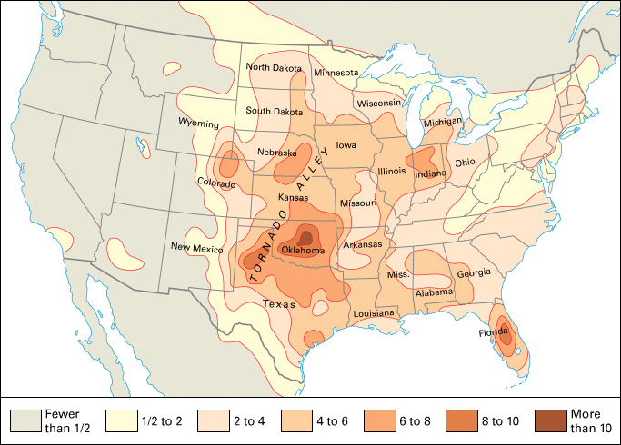
This map of the United States shows the number of tornadoes that occur yearly in each 10,000 square miles (25,900 square kilometers) of area. (World Book map)

Oklahoma is one of the states in “Tornado Alley,” a belt that stretches across the Midwestern and Southern states that has a very high incidence of tornadoes. Moore was the site of one of the most destructive tornadoes in U.S. history. On May 3, 1999, a tornado ripped through the area, killing 42 people. That tornado was an EF-5, with the highest recorded wind speeds in history, at 302 miles (486 kilometers) per hour.

Additional World Book articles:

  • Twisted—More Terrible Tornadoes (a Special Report)
  • Weather 1999 (a Back in Time article)

Tags: oklahoma, storm, tornado, tornado alley
Posted in Current Events, Natural Disasters, Weather | Comments Off

Savage Winter Storm Leaves Six Dead in the U.S. on Christmas

Wednesday, December 26th, 2012

December 26, 2012

A powerful winter storm brought a white Christmas to the U.S. Midwest and tornadoes to the South. Little Rock, Arkansas, received 9 inches (91 centimeters) of snow, breaking a December 25 snowfall record that had stood for 86 years, and blizzard conditions hampered holiday travel in parts of Missouri, Kentucky, Illinois, Indiana, and Ohio.

The National Weather Service reported the sighting of more than 30 tornadoes in a line stretching from Texas and Louisiana to Mississippi and Alabama. Hardest hit was Mobile, Alabama, where numerous twisters and brutal, straight-line winds knocked down countless trees, blew off roofs, and left thousands of households without electric power on Christmas Day.

(Credit: © Colin McPherson, Corbis)

The storm caused the deaths of at least six people, primarily victims of car accidents on snow- and sleet-slickened highways in Arkansas and Oklahoma. One man was killed in Houston, Texas, when a tree fell on his pickup truck.

The same storm system is currently moving eastward, threatening the Carolinas. By the end of the week, it was expected to move up into the Northeast, with 12 inches (30 centimeters) of snow predicted.

Additional World Book articles:

  • Weather
  • The Forecast: Better Weather Prediction Ahead (a special report)
  • Weather Terms—Cloudy or Clear? (a special report)


Tags: blizzard, christmas, record snowfall, storm, tornado
Posted in Current Events, Environment, Holidays/Celebrations, Natural Disasters, Weather | Comments Off

  • Most Popular Tags

    african americans ancient greece archaeology art australia barack obama baseball bashar al-assad basketball black history month china climate change conservation earthquake european union football france global warming iraq isis japan language monday literature major league baseball mars mexico monster monday mythic monday mythology nasa new york city nobel prize presidential election russia space space exploration syria syrian civil war Terrorism ukraine united kingdom united states vladimir putin women's history month world war ii