Happy Earth Day!
Friday, April 21st, 2023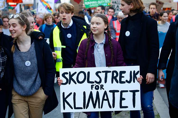
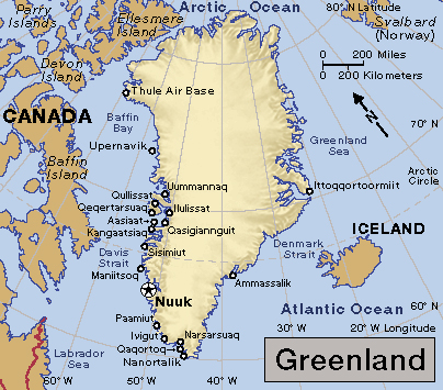
The Swedish environmental activist Greta Thunberg (holding sign) marches in a 2019 protest organized by students. As a teenager, Thunberg became known for her boldness in confronting adult politicians for their inaction on climate change due to global warming.
Credit: © Alexandros Michailidis, Shutterstock
This Saturday, April 22, is Earth Day, an annual observance to increase public awareness of environmental issues. Each year on Earth Day, millions of people throughout the world gather to clean up litter, protest threats to the environment, and celebrate progress in reducing pollution.
Earth Day began in the United States. In 1969, the U.S. Senator Gaylord A. Nelson suggested that a day of environmental education be held on college campuses. The following year, the lawyer and environmentalist Denis Hayes, then a recent graduate of Stanford University, led hundreds of students in planning and organizing the observance of Earth Day on April 22, 1970. About 20 million people participated in this celebration.
The observance of Earth Day in 1970 helped alert people to the dangers of pollution and stimulated a new environmental movement. That same year, Congress created the Environmental Protection Agency to set and enforce pollution standards. Congress also passed the Clean Air Act of 1970, which limited the amount of air pollution that cars, utilities, and industries could release. Other new environmental laws soon followed.
One modern champion for the environment is the Swedish activist Greta Thunberg. She has worked to convince politicians to take action against climate change due to global warming. Global warming is an observed increase in Earth’s average surface temperature. As a teenager, Thunberg became known for her boldness in confronting adult politicians for their inaction on climate change. She has called upon leaders to reduce emissions of greenhouse gases, mainly carbon dioxide. Such gases trap heat in the atmosphere, warming the planet’s surface.
Thunberg was born in Stockholm, Sweden, on Jan. 3, 2003. She was diagnosed with autism spectrum disorder at a young age. As a child, she showed an interest in environmental issues. She convinced her family to reduce their carbon footprint by becoming vegan and giving up air travel. Carbon footprint is a measure of the greenhouse gas emissions associated with human activities.
In 2018, at the age of 15, Thunberg protested for action on climate change outside the Swedish parliament, inspiring other student protesters. Together, they organized school strikes to demand action on climate change. In August 2019, Thunberg sailed across the Atlantic Ocean from Plymouth, in the United Kingdom, to New York City, in the United States, on a “carbon neutral” voyage. Thunberg sailed aboard a yacht that got its electric power from solar panels and underwater turbines. While in the United States, she addressed the United Nations as part of its Climate Action Summit. During her speech, she announced that she and a group of other children were filing a lawsuit against five nations not on track to meet their emission-reduction targets under the Paris Agreement. The Paris Agreement is a global treaty designed to fight global warming.
Thunberg is the author of several books on climate change activism. No One Is Too Small to Make a Difference (2019) is a collection of Thunberg’s speeches. Our House Is on Fire (2020), a memoir by Thunberg and her family, tells how Thunberg’s personal struggles led her to become an activist. Thunberg’s best seller The Climate Book (2023) explains how the climate is changing and calls on society to adopt effective strategies to slow climate change.