Behind the Headlines – World Book Student
  • Search

  • Archived Stories

    • Ancient People
    • Animals
    • Arts & Entertainment
    • Business & Industry
    • Civil rights
    • Conservation
    • Crime
    • Current Events
    • Current Events Game
    • Disasters
    • Economics
    • Education
    • Energy
    • Environment
    • Food
    • Government & Politics
    • Health
    • History
    • Holidays/Celebrations
    • Law
    • Lesson Plans
    • Literature
    • Medicine
    • Military
    • Military Conflict
    • Natural Disasters
    • People
    • Plants
    • Prehistoric Animals & Plants
    • Race Relations
    • Recreation & Sports
    • Religion
    • Science
    • Space
    • Technology
    • Terrorism
    • Weather
    • Women
    • Working Conditions
  • Archives by Date

Posts Tagged ‘africa’

« Older Entries

Our Earliest Ancestor

Monday, September 30th, 2019

September 30, 2019

Last month, in late August, scientists published a description of a 3.8-million-year-old fossil skull, allowing people to gaze into the face of perhaps our earliest ancestor, Australopithecus anamensis. According to one researcher, the remarkable fossil is the most complete skull of the “oldest-known species” of the human evolutionary tree. The important fossil helps define the ancient human evolutionary family, but it also brings more questions to the often cloudy relationships among that family’s members.

Paleontologists have discovered a near-complete skull of Australopithecus anamensis.  Credit: © Dale Omori, Cleveland Museum of Natural History

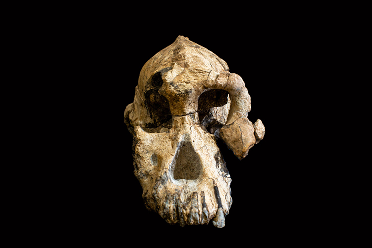
Paleontologists discovered the near-complete skull of Australopithecus anamensis in Ethiopia in 2016. Credit: © Dale Omori, Cleveland Museum of Natural History

A. anamensis belongs to the hominin group of living things that includes human beings and early humanlike ancestors. A team of paleontologists led by Yohannes Haile-Selassie from the Cleveland Museum of Natural History found the hominin skull in 2016 at a site called Woranso-Mille in the Afar region of Ethiopia. The fossil, officially known as MRD-VP-1/1 (MRD for short), was discovered in two halves that fit together, making up a nearly complete skull. The skull’s position in volcanic sediments enabled scientists to determine its age—3.8 million years—with great precision. The anatomical features of the skull helped identify it as A. anamensis, one of the earliest known hominin species. This species was first identified from a handful of fossil skull fragments and other bones discovered at Lake Turkana in northern Kenya in the 1990’s. Those specimens are between 4.2 million and 3.9 million years old.

Facial reconstruction of Australopithecus anamensis.  Credit: © John Gurche/Matt Crow, Cleveland Museum of Natural History

Scientists used the fossilized Australopithecus anamensis skull to create this image of one of humankind’s earliest ancestors. Credit: © John Gurche/Matt Crow, Cleveland Museum of Natural History

The MRD skull shows that A. anamensis had a small brain, a bit smaller than that of a modern chimpanzee. The skull more closely resembles an ape than a modern human, with a large jaw and prominent cheekbones, but the canine teeth are much smaller and more humanlike. And, like humans, A. anamensis walked upright on two legs. Sediments and other fossils show that the region where the skull was found was arid, but the ancient creature died in a vegetated area near a small stream that entered a lake.

The site in Ethiopia where MRD was discovered is not far from the village of Hadar, where fossils of another early hominin, Australopithecus afarensis, were first discovered in 1974. A. afarensis is known mainly from the partial skeleton of an adult female, the famous “Lucy,” found in deposits dating to about 3.2 million years ago. Other A. afarensis fossils date to nearly 3.8 million years ago, which suggests Lucy and her kind may have coexisted with A. anamensis.

Most scientists, however, think that Lucy and her kind evolved from A. anamensis, and that the transition occurred as one species disappeared and the other took over. Scientists now understand that A. anamensis could still be ancestral to Lucy, but that other A. anamensis populations continued to thrive unchanged as her neighbors. The prehistoric landscape of East Africa had many hills, steep valleys, volcanoes, lava flows, and rifts that could easily have isolated populations over many generations. Over time, the populations eventually diverged. Scientists think that one of these species eventually gave rise to Homo, the human genus.

Tags: africa, ancient humans, australopithecus afarensis, australopithecus anamensis, ethiopia, lucy, paleoanthropology, science
Posted in Ancient People, Current Events, Education, History, People, Prehistoric Animals & Plants, Science | Comments Off

Pope Francis and the “Three M’s”

Monday, September 9th, 2019

September 9, 2019

Tomorrow, September 10, Pope Francis returns to Rome after a six-day apostolic trip to the east African nation of Mozambique and the nearby island nations of Madagascar and Mauritius—the “Three M’s” of the Indian Ocean. Apostolic is another word for papal or having to do with the pope. Throughout the trip, enthusiastic crowds turned out to welcome the pope, who travelled to the three nations as “a pilgrim of peace, hope, and reconciliation.” Francis has been leader of the Roman Catholic Church since 2013.

Pope Francis.  Credit: © Giulio Napolitano, Shutterstock

Pope Francis is concluding a trip to Mozambique, Madagascar, and Mauritius. Credit: © Giulio Napolitano, Shutterstock

On September 4, Francis arrived in Maputo, the capital of Mozambique, where about 40 percent of the people are Catholic. (Madagascar and Mauritius have Catholic populations of roughly 30 percent.) On September 5, the pope visited Mozambique President Filipe Nyusi at the Palácio da Ponta Vermelha (Palace of the Red Point), the president’s official residence. Francis then met with civil and religious authorities and members of the diplomatic corps. He hosted an interreligious prayer meeting with young people before paying a private visit to the “Matthew 25″ House, which helps homeless and impoverished children. On September 6, Francis visited Zimpeto Hospital and celebrated Mass before some 60,000 people at Zimpeto Stadium. (Zimpeto is an area of Maputo.) He then departed for Antananarivo, the capital of Madagascar.

Click to view larger image Mozambique Credit: WORLD BOOK map

Click to view larger image
Maputo is at the southern tip of Mozambique. Madagascar lies across the Mozambique Channel. Credit: WORLD BOOK map

On September 7, Francis visited President Andry Rajoelina at the Iavoloha Palace just outside Antananarivo. Formal meetings then preceded a prayer service at the Monastery of the Discalced Carmelites and a visit to the tomb of the Blessed Victoire Rasoamanarivo (1848-1894), a Malagasy woman who dedicated her life to helping the poor of Madagascar. Pope John Paul II beatified Rasoamanarivo (declared her among the blessed in heaven) in 1989. On Sept. 8, 2019, Pope Francis celebrated Mass before visiting the Akamasoa City of Friendship foundation for the poor. He led a prayer for workers and met with religious officials before leaving for Port Louis, the capital of Mauritius, on September 9.

Click to view larger image Mauritius. Credit: WORLD BOOK map

Click to view larger image
Port Louis lies on the west coast of Mauritius. Credit: WORLD BOOK map

Francis began his day (today) in Mauritius with a Mass at the Monument of Mary Queen of Peace in Port Louis. The pope then visited the shrine of the French Catholic priest and missionary Père Jacques-Désiré Laval (1803-1864). Laval (also beatified by John Paul II) dedicated his life to helping the poor and sick of Mauritius, and his shrine is said to have miraculous qualities. The day of Laval’s death, September 9—the day of the pope’s visit—is a special day of celebration and reverence for Catholics of the region. Francis then met with Prime Minister Pravind Jugnauth and acting President Barlen Vyapoory before returning by plane to Antananarivo. Tomorrow, September 10, a final ceremony at Ivato International Airport precedes his scheduled return flight to the Vatican in Rome.

Francis is from Argentina. He is the first pope from Latin America and the first Jesuit pope. Jesuits are members of a religious order called the Society of Jesus. Francis is known for his commitment to social justice, especially for the poor; his humble lifestyle; and his conservative religious beliefs. Francis visited Panama for World Youth Day in January 2019, and in February he became the first pope to visit the United Arab Emirates. Francis travelled to Morocco in March and to the Balkan states of Bulgaria, North Macedonia, and Romania in May and June.

Tags: africa, madagascar, mauritius, mozambique, pope, pope francis
Posted in Current Events, People, Religion | Comments Off

Recovering from Cyclone Idai

Friday, April 26th, 2019

April 26, 2019

Last month, in March, Tropical Cyclone Idai struck the southeastern coast of Africa. One of the strongest storms ever recorded in the Southern Hemisphere, Idai caused catastrophic landslides and flooding that killed more than 1,000 people in Mozambique and in neighboring Malawi and Zimbabwe. The storm left more than 300,000 people homeless and led to deadly outbreaks of cholera and increased cases of malaria. More than a month later, thousands of people remain missing in affected areas, and government and international aid agencies continue to struggle to provide badly needed food, water, and medical supplies.

An owner (2nd R) stays at his destroyed bar after the cyclon Idai hit near the beach in Beira, Mozambique, on March 23, 2019. - The death toll in Mozambique on March 23, 2019 climbed to 417 after a cyclone pummelled swathes of the southern African country, flooding thousands of square kilometres, as the UN stepped up calls for more help for survivors. Cyclone Idai smashed into the coast of central Mozambique last week, unleashing hurricane-force winds and rains that flooded the hinterland and drenched eastern Zimbabwe leaving a trail of destruction. Credit: © Yasuyoshi Chiba, AFP/Getty Images

On March 23, 2019, residents of Beira, a coastal city in central Mozambique, survey the damage done by Cyclone Idai. Credit: © Yasuyoshi Chiba, AFP/Getty Images

Cyclone Idai formed as a tropical depression over the warm waters of the southwestern Indian Ocean in early March. The storm intensified into a cyclone as it struck central Mozambique on March 4. Torrential rains and deadly winds whipped coastal areas for days as Idai spun along the Mozambique Channel between the African mainland and the island of Madagascar. Idai varied in strength, until reaching peak intensity with winds of 150 miles (240 kilometers) per hour on March 14. After 17 days of damage and deluge, the storm finally weakened and dissipated on March 21.

Intense Tropical Cyclone Idai approaching the Sofala province of Mozambique on 14 March 2019, shortly after reaching its peak intensity. Credit: NASA

This satellite image shows Cyclone Idai in the Mozambique Channel on March 14, 2019. Credit: NASA

The broad and determined storm reached inland to Malawi and Zimbabwe and pelted coastal areas of Madagascar. The storm extensively damaged or destroyed vital infrastructure, including communication networks, hospitals, roads, sanitation facilities, and schools. Wide swaths of farmland were ruined, portions of forests were flattened by high winds, and flooding created a temporary inland sea in Mozambique that measured some 80 miles (130 kilometers) long and 15 miles (24 kilometers) wide. Mozambique President Filipe Nyusi called Cyclone Idai a “humanitarian disaster of great proportion.”

Click to view larger image Mozambique Credit: WORLD BOOK map

Mozambique. Credit: WORLD BOOK map

Mozambique’s typically able Instituto Nacional de Gestão de Calamidades (National Disasters Management Institute) was overwhelmed by the scale of Idai’s destruction, and an urgent note verbale (formal diplomatic notice) went out requesting international help. The Red Cross and Red Crescent, Doctors Without Borders, and several United Nations organizations came to the rescue, as did the European Union and the governments of Canada, France, Portugal, South Africa, and the United Kingdom.

Cyclone Idai was the seventh tropical cyclone of the Indian Ocean season, more than twice the average for this time of year. Globally, high-intensity storms have been occurring more frequently in recent years, a trend directly related to climate change. Global warming increases sea temperatures, creating more moisture and instability in the atmosphere—factors crucial to the birth of dangerous cyclones and hurricanes. Tropical cyclones need high humidity and surface water temperatures of 79 °F (26 °C ) or higher to form. Melting glaciers and ice have increased global sea levels, resulting in more frequent and intense flooding in coastal areas around the world.

Tags: africa, climate change, cyclone, cyclone idai, disasters, global warming, indian ocean, malawi, mozambique, zimbabwe
Posted in Current Events, Disasters, Environment, Health, Natural Disasters, People, Weather | Comments Off

Equatorial Guinea 50

Friday, October 12th, 2018

October 12, 2018

Today, October 12, the Republic of Equatorial Guinea celebrates the 50th anniversary of its independence in 1968. Equatorial Guinea consists of a territory on the west coast of Africa, plus five offshore islands. Most of the nation’s people live in the mainland territory, Río Muni, which lies between Cameroon and Gabon. The largest island, Bioko, is in the Gulf of Guinea, about 100 miles (160 kilometers) northwest of Río Muni. The other islands—Corisco, Elobey Chico, Elobey Grande, and Annobón—are southwest of Río Muni. Prior to independence, Equatorial Guinea was a Spanish territory and colony.

The flag of Equatorial Guinea has ( top to bottom ) green, white, and red horizontal stripes, and a blue triangle at the staff. The national coat of arms is on the white stripe. The flag was used from 1969 to 1978 and was readopted in 1979. Credit: © Loveshop/Shutterstock

The flag of Equatorial Guinea includes a crest with a silk-cotton tree, six stars representing the nation’s mainland and five islands, and a banner reading Unidad, Paz, Justicia (Unity, Peace, Justice). Credit: © Loveshop/Shutterstock

President Teodoro Obiang Nguema Mbasogo led golden jubilee celebrations in Malabo, the nation’s capital on Bioko. (A new capital called Ciudad de la Paz—City of Peace—is under construction in Río Muni, and parts of the government already operate from there.) Celebrations also took place in Bata, the nation’s largest city, and other cities and towns freshly “cleaned and smartened” for the anniversary.

Click to view larger image Equatorial Guinea. Credit: WORLD BOOK map

Click to view larger image
Equatorial Guinea. Credit: WORLD BOOK map

Portuguese sailors landed on Annobón in 1471 and later claimed Annobón, Bioko, and part of the nearby mainland. Spain took control of these territories in the mid-1800’s and made them a colony in 1959. In 1968, shortly after Equatorial Guinea gained independence, Francisco Macías Nguema seized power as president and dictator. After a decade of violent rule, a group of army officers led by Obiang Nguema overthrew Macías in 1979. The group established a military government with Obiang Nguema as president. He has since been reelected numerous times against little opposition.

Malabo, Capital of Equatorial Guinea. Credit: Ipisking (licensed under CC BY-SA 3.0)

Malabo, the capital of Equatorial Guinea, lies on Venus Bay on the island of Bioko. Credit: Ipisking (licensed under CC BY-SA 3.0)

About 80 percent of Equatorial Guinea’s people live in Río Muni. Most of the people in Río Muni are members of the Fang ethnic group. The Fang are closely related to the people of neighboring Cameroon and Gabon. Most of the people of Bioko belong to the Fernandino or Bubi ethnic groups.

Tags: africa, equatorial guinea, golden jubilee, malabo
Posted in Current Events, Government & Politics, History, Holidays/Celebrations, People | Comments Off

Swaziland 50

Thursday, September 6th, 2018

September 6, 2018

Today, the small southern African nation of Swaziland celebrates its golden jubilee, the 50th anniversary of Swazi independence on Sept. 6, 1968. Swaziland, nestled between Mozambique and the Republic of South Africa, was formerly a British protectorate. It became independent in 1968 as the Kingdom of Swaziland, and the nation remains a monarchy. Today in Mbabane, the Swazi capital, anniversary celebrations were muted amid an ongoing economic crisis in the country.

Swaziland's flag has five horizontal stripes. The top and bottom stripes are blue (for peace). The wide center stripe is red (for past battles) with a black and white shield, spears, and staff. Between the blue and red stripes are yellow stripes (for natural resources). Credit: © Loveshop/Shutterstock

Swaziland’s flag has five horizontal stripes. The top and bottom stripes are blue (for peace). The wide center stripe is red (for past battles) with a black and white shield, spears, and staff. Between the blue and red stripes are yellow stripes (for natural resources). Credit: © Loveshop/Shutterstock

Despite the crisis, Swaziland’s King Mswati III began celebrating the nation’s 50th anniversary with his own 50th birthday party on April 19, 2018. Mswati’s “50/50 Celebrations” showcased Swazi culture and traditions, as well as the king’s own immense personal wealth. During the party, he suggested renaming the kingdom eSwatini, the nation’s original name before it was anglicized to Swaziland. The name eSwatini means land of the Swazis in the local siSwati language.

Protests and criticism of the king’s lavish lifestyle led him to cancel expensive anniversary celebrations planned for September. Most Swazi people are poor, surviving almost entirely on what they can grow or raise through subsistence agriculture.

Click to view larger image Swaziland Credit: WORLD BOOK map

Click to view larger image
Swaziland. Credit: WORLD BOOK map

The vast majority of Swaziland’s people belong to the Swazi ethnic group. According to the legends of the Swazi, their ancestors once lived near what is now Maputo, Mozambique. In the late 1700′s, the Swazi chief Ngwane II led a small band of people over the mountains to what is now southeastern Swaziland. There the Swazi found other African peoples. Ngwane II and the chiefs who ruled after him united several of these peoples with the Swazi.

Mbabane, the administrative capital of Swaziland, lies in the country's western highlands. Most of the people of Swaziland live in rural areas. Credit: SuperStock

Mbabane, the administrative capital of Swaziland, lies in the country’s western highlands. Most of the people of Swaziland live in rural areas. Credit: SuperStock

British traders and Boers (chiefly Dutch farmers from South Africa) first came to Swaziland in the 1830′s. In the 1880′s, the settlers discovered gold. Hundreds of prospectors rushed into the region. They asked the Swazi chief and his advisers to sign documents granting them rights to mine minerals and to use land for farming and grazing. The Swazi leaders could not read and did not realize that they were giving up control of the land.

In 1894, the British and Boers agreed that the South African Republic, a Boer state, would govern Swaziland. But in 1902, the Boers lost a war with the British, and the United Kingdom took control of Swaziland. The United Kingdom ruled Swaziland until the mid-1960′s. In 1967, Swaziland gained control over its internal matters. It received full independence on Sept. 6, 1968. On Sept. 24, 1968, Swaziland became a member of the United Nations.

Tags: africa, golden jubilee, swaziland, united kingdom
Posted in Current Events, Government & Politics, History, People | Comments Off

Baobabs in Danger

Thursday, July 26th, 2018

July 26, 2018

The baobab, one of the world’s most unusual and iconic trees, is in danger. The gigantic baobab, known as the “tree of life,” can live as long as 3,000 years. But the hardy trees are suddenly dying in unusual numbers, many long before their expected life spans. Climate change has increased the occurrence of such weather anomalies as droughts, floods, and lightning storms, all of which can harm or kill baobab trees. A destructive mold called black fungus is also appearing more frequently on baobab trees. The tree is further threatened by the loss of its natural habitat to agriculture and development. Habitat loss and illegal hunting have also greatly reduced the population of African elephants, the animals largely responsible for spreading the tree’s seeds. If no action is taken to protect the baobab and its environment, certain species of the tree could be extinct within 100 years.

Baobab Alley, Madagascar. Credit: © Monika Hrdinova, Shutterstock

These giant baobabs form part of the magnificent Avenue of the Baobabs in the Megabe region of western Madagascar. Credit: © Monika Hrdinova, Shutterstock

Baobab is the name of a group of trees that grow in tropical and subtropical regions of the Eastern Hemisphere, especially in Madagascar. The best-known type of baobab is found on the African mainland. It has an extremely thick, often bulging, trunk. This tree may grow to 80 feet (24 meters) tall with a trunk from 30 to 50 feet (9 to 15 meters) in diameter. The tree has white flowers that open at night and are pollinated by bats. The fruit, called monkey bread, is almost 1 foot (30 centimeters) long. It dangles from the tree like a lantern from a long, ropy stem. The fruit holds many seeds buried in a mealy pulp. The pulp, which is rich in vitamin C, serves as food for both animals and people, and it is also used to flavor cool drinks. People sometimes use the leaves and bark in medicines. They make paper, cloth, and rope from the bark fibers. The giant trees also provide shade in the hot climates where they grow, serving as cool gathering places for animals and humans alike.

African elephants, who are themselves in danger, help propagate baobabs by eating the tree’s fruit and seeds (antelopes, baboons, and other animals also contribute). The seeds pass through the animal’s digestive system, and they are then dropped in ready-made fertilizer. Elephants tend to walk great distances in search of food and water, and a single tree’s seeds can thus be spread out over many miles. Ironically, elephants are also known to damage or kill baobab trees in times of severe drought. Elephants sometimes rip apart a baobab’s trunk to get at the tree’s bountiful water supply inside.

Adrian Patrut, a chemist at Babeș-Bolyai University in Romania, has led an international research study on baobab trees since 2005. Patrut pioneered a radiocarbon technique to date baobabs, which do not have the tell-tale age rings found in most trees. Patrut and his team have kept close tabs on the largest and oldest baobabs in southern Africa. They found that 9 of the 13 oldest recorded baobabs (between 1,100 and 2,500 years old) and 5 of the 6 largest have died in the past 12 years—an alarming death rate among these long-living trees. Parts of many other baobabs have also died. The trees have multiple core systems within their massive trunks, allowing parts of the tree to die while the rest lives on.

Of the nine species of baobab trees, six are endemic to the African island of Madagascar. Of those six, half are on the Red List of Threatened Species compiled by the International Union for the Conservation of Nature and Natural Resources (IUCN). The numbers of three Madagascar baobabs—Adansonia grandidieri, Adansonia perrieri, and Adansonia suarezensis—have dropped more than a 50 percent since the 1950′s. A. perrieri and A. suarezensis are considered critically endangered. The numbers of the remaining baobab species that live in mainland Africa, the Arabian peninsula, and Australia are also on the decline.

Tags: africa, baobab, baobab tree, climate change, drought, elephants, global warming, madagascar
Posted in Animals, Conservation, Current Events, Environment, People, Plants | Comments Off

Language Monday: Bemba

Monday, January 29th, 2018

January 29, 2018

In Bemba, the language of a large ethnic group living in northeastern Zambia of south-central Africa, lelo nipali Cimo means today is Monday. After Zambia’s official language, English, Bemba is the nation’s most common tongue. More than 4 million people speak Bemba or related dialects as their first language. It is also a common lingua franca in the region. A lingua franca is a language that allows people who do not share a common native language to communicate. Millions of other people in south-central Africa speak Bemba as a second or third language.

Click to view larger image Zambia. Credit: WORLD BOOK map

Click to view larger image
Ulubemba, the traditional homeland of the Bemba people, includes parts of northeastern Zambia. Credit: WORLD BOOK map

According to Bemba folklore, their people once lived in a kingdom called Kola that was part of the ancient Luba Empire in what is now the Democratic Republic of the Congo. There, the Bemba lived under the rule of a great chief called Mukulumpe Mubemba. The name Bemba is derived from that chief’s name. After a series of bitter quarrels within the royal family, the chief’s sons fled with a group of followers. After much traveling and many battles, the sons and their followers settled in what is now northeastern Zambia. They set up a society with a paramount chief, called Chitimukulu (The Great Tree) in the Bemba language. Today, the position of Chitimukulu still exists and has a strong advisory role within the national government of Zambia.

Throughout history, Bemba people have lived mostly as farmers. However, they were viewed as a fierce, warlike people by early European travelers and explorers. The British colonized what is now Zambia in the 1890’s. They called the region Northern Rhodesia. In the 1920’s, the discovery of large copper ore deposits in south-central Africa brought a rush of Bemba speakers from the countryside to towns for jobs in the copper mines of Zambia and nearby nations.

By the 1940’s, an urban dialect (variety of language) known as “Town Bemba” became the main language in the “copperbelt” of south-central Africa. Town Bemba illustrates the dynamic character of many African languages as they evolved in response to colonization and urbanization. Town Bemba incorporates many terms from British English. Many American English terms have also entered the Bemba lexicon (collection of words) through international business relationships, television, and popular music.

Tags: africa, bemba, language monday, zambia
Posted in Arts & Entertainment, Education, Government & Politics, History, People | Comments Off

Benin’s Vodou Day

Wednesday, January 10th, 2018

January 10, 2018

Today, January 10, is Vodou Day, a religious holiday in the small west African nation of Benin. Often mistakenly associated with black magic (magic performed with the aid of evil spirits), Vodou (also spelled Voudou or Voodoo) is an official religion in Benin. Like other religions, Vodou has at its core a creator being as well as a number of spirits. Vodou’s set of beliefs, traditions, and practices are taken largely from traditional African religions as well as from Roman Catholicism. For followers of Vodou—known as Vodouisants—the religion is a way of life, and it influences art, culture, dance, language, medicine, music, and philosophy.

OUIDAH, BENIN - Jan 10, 2017: Unidentified Beninese women in national suit wear necklace and earings at the voodoo festival, which is anually celebrated on January, 10th. Credit: © Anton Ivanov, Shutterstock

Women attend annual Vodou Day festivities in Ouidah, Benin. Credit: © Anton Ivanov, Shutterstock

Vodou originated in Benin and nearby areas. Vodou comes from a word in the local Fon language meaning spirit. People forced into slavery brought the religion to Brazil, the Caribbean, and parts of the United States. (Vodou is also an officially recognized religion in Haiti.) Vodouisants believe that each person has a protector spirit, usually inherited from an ancestor. Protector spirits can reward individuals with luck or wealth. They can also punish people with misfortune or illness. Vodouisants believe that spirits commonly possess people and can speak, give advice, and tell stories about the past. Other Vodou spirits include zombies (animated or living corpses) and the mighty python god, Dangbe. Vodou rituals often include elaborate dances, costumes, music, and animal sacrifice. Natural oils, incense, and alcoholic drinks also figure prominently in Vodou ceremonies.

Followers of Vodou, called Vodouisants, participate in a memorial ceremony in Haiti. They wear white clothing to symbolize mourning. Africans brought Vodou beliefs to Haiti in the 1700’s. Credit: © Kena Betancur, Reuters/Landov

Followers of Vodou, called Vodouisants, participate in a memorial ceremony in Haiti. They wear white clothing to symbolize mourning. Africans brought Vodou beliefs to Haiti in the 1700’s. Credit: © Kena Betancur, Reuters/Landov

Ouidah, a city on the narrow Beninese coast, is the center of the nation’s Vodou Day festivities. Many thousands of Vodouisants gather at the city’s Point of No Return, a coastal monument to the millions of Africans who were enslaved and taken away to foreign lands. There, Vodou priests lead a number of ceremonies and rituals throughout the day. On Vodou Day, as well as throughout the year, the streets of Ouidah are adorned with Vodou symbols, statues, and fetishes (objects with spiritual or magical powers). The Musée d’Histoire d’Ouidah (History Museum of Ouidah) tells the tragic history of the slave trade in the area, but the museum is sometimes referred to as the “Voodoo Musuem” because of its extensive Vodou collections.

Click to view larger image This map shows the areas along the west coast of Africa, near the Gulf of Guinea, where most of the African slave trade occurred. Most of the slaves were taken from the Bantu, Hausa, Igbo, Malinke, Ouidah, Oyo, and Yoruba groups. The groups that captured the most Africans for European and American slave traders were the Ashanti, Benin, Dahomey, Efik, Fante, Ga, Kongo, and Ndongo. The slaves taken in these areas were carried across the Atlantic Ocean to the Caribbean Islands and sold. Credit: WORLD BOOK map

Click to view larger image
Ouidah, Benin, was one of several ports along the west coast of Africa, near the Gulf of Guinea, where most of the African slave trade occurred. Credit: WORLD BOOK map

Tags: africa, benin, religion, vodou
Posted in Animals, Current Events, History, Holidays/Celebrations, Religion | Comments Off

Zimbabwe’s Power Transfer

Tuesday, December 5th, 2017

December 5, 2017

On Nov. 24, 2017, Emmerson Mnangagwa was sworn in as the new president of Zimbabwe, a landlocked country in southern Africa. The transfer of government power is routine in many countries, taking place every few years or even more frequently. In Zimbabwe, however, this has not been the case. Mnangagwa’s presidency followed the 37-year reign of President Robert Mugabe—a period that covers the entire short and volatile history of the Republic of Zimbabwe.

Emmerson D. Mnangagwa, Minister of Justice, Legal and Parliamentary Affairs of Zimbabwe during High Level Segment of the 25th Session of the Human Rights Council. 5 March 2014. Credit: Jean-Marc Ferré, UN Photo

Emmerson Mnangagwa became Zimbabwe’s second president on Nov. 24, 2017. Credit: Jean-Marc Ferré, UN Photo

Since the late 1800′s, the area that is now Zimbabwe has had a troubled, often violent, political history. The vast majority of Zimbabwe’s people are black Africans, but whites (and the United Kingdom) controlled the country from about 1890 to 1979. During the last decade of white rule, black nationalists in Zimbabwe—then called Rhodesia—engaged in guerrilla warfare against the government. The first black-majority government was elected in 1979. However, many people rejected this government, and guerrilla violence continued. A cease-fire led to new elections in 1980, and Robert Mugabe, one of the principal rebel leaders, became prime minister (and later president) of the independent nation of Zimbabwe.

President of Zimbabwe and Chairman of the African Union Robert Mugabe. Credit: The Office of the President of Russia (licensed under CC BY 4.0)

President Robert Mugabe dominated Zimbabwe politics for 37 years. Credit: The Office of the President of Russia (licensed under CC BY 4.0)

After gaining power, Mugabe faced down armed rebellions and decades of political opposition. He also won numerous disputed elections often marred by violence and voter intimidation. His policies benefited political allies and parts of the nation’s population (and greatly enriched himself and his family), while people who resisted his rule often lost their homes, their land—even their freedom. Zimbabwe’s economy suffered badly under Mugabe, and millions of people lived in abject poverty.

In 2017, Mugabe—now 93 years old and perhaps sensing the end was near—finally pushed things too far. On November 6, Mugabe fired Vice President Mnangagwa, clearing the way for Grace Mugabe, his 52-year-old wife, to take the post and succeed him as president at the end of his term in 2018. After the firing, Mnangagwa fled to South Africa, and the seeds of unrest sprouted in Harare, Zimbabwe’s capital city and long a hotbed of anti-Mugabe sentiment.

On November 14, Zimbabwe’s military turned against Mugabe, and tanks rumbled through the streets of Harare. On November 15, Mugabe was placed under house arrest (purportedly for his own safety), but the military denied that it had staged a coup d’etat (forced government takeover). Violent protests called for Mugabe to officially step down, but he initially refused. Finally, on November 21, as Zimbabwe’s parliament began impeachment proceedings to remove Mugabe, the self-styled “Grand Old Man” of African politics resigned.

Emmerson Mnangagwa (who is 75 years old) reentered the country on November 22. Two days later he became just the second president in Zimbabwe’s history. The position is potentially a temporary one, as he is listed as an interim replacement until elections scheduled for September 2018.


Tags: africa, emmerson mnangagwa, robert mugabe, zimbabwe
Posted in Current Events, Government & Politics, People | Comments Off

Djibouti at 40

Tuesday, June 27th, 2017

June 27, 2017

On June 27, 1977, forty years ago today, in a hot, dusty corner of northeastern Africa, the French Territory of the Afars and Issas became the independent nation of Djibouti. The Afars and the Issas—two traditionally nomadic ethnic groups—make up most of Djibouti’s population of nearly 1 million people. Djibouti gained independence in 1977 from France, which had controlled the Djibouti area since the 1880’s.

Members of the Djiboutian Armed Forces shout cadences while marching during the Djibouti Independence Day parade June 27, 2016, at Djibouti. Today marked the 39th year since Djibouti declared its independence. Credit: Staff Sgt. Eric Summers Jr., U.S. Air Force

Soldiers shout cadences while marching in the independence day parade in Djibouti. Today, June 27, 2017, marks 40 years since Djibouti gained independence in 1977. Credit: Staff Sgt. Eric Summers Jr., U.S. Air Force

A large celebration to mark the nation’s 40th birthday took place in Djibouti city, the capital. A vibrantly dressed crowd braved the 108 °F (42 °C) temperature—typical for this time of year—to cheer a military parade featuring marching bands, high-stepping and chanting soldiers, and stunt-performing police officers. President Ismaïl Omar Guelleh and Prime Minister Abdoulkader Kamil Mohamed attended the event, as did foreign troops and dignitaries from China, France, Japan, and the United States. Those four countries have military bases in the strategically-located country, and a Saudi Arabian base will soon join them. Djibouti hosts Camp Lemonnier, the largest U.S. permanent military base in Africa.

Click to view larger image Djibouti. Credit: WORLD BOOK map

Click to view larger image
Djibouti. Credit: WORLD BOOK map

Djibouti lies on the western shore of the Gulf of Aden. Djibouti’s location has helped make the capital a major port, and ships from all over the world regularly stop there. Strategically, control of Djibouti can determine which ships pass through the narrow Strait of Bab el Mandeb, a bottleneck for vessels traveling between the Indian Ocean and the Mediterranean Sea. The strait is one of the busiest maritime routes in the world.

Lake Assal lies in Djibouti, a country in northeastern Africa. The salt lake lies 509 feet (155 meters) below sea level, making it the lowest point on the African continent. Credit: © Thinkstock

The terrain of Djibouti is extremely desolate. The nation’s Lake Assal, seen here, is a salt lake that lies 509 feet (155 meters) below sea level. It is the lowest point on the African continent. Credit: © Thinkstock

France founded a coaling station in the Djibouti area in 1881. The French then created a territory called French Somaliland and founded the city of Djibouti. In 1896, Djibouti—already a prosperous port—became the territorial capital. In 1958, French Somaliland joined the French Community, an organization that linked France and its overseas territories.

In 1967, French Somaliland voted to continue its association with France and was renamed the French Territory of the Afars and Issas. But opposition to French rule steadily grew, and in May 1977, the people voted overwhelmingly for independence. The territory became the independent nation of Djibouti a month later.

Tags: africa, djibouti, gulf of aden
Posted in Current Events, Government & Politics, History, Holidays/Celebrations, People | Comments Off

  • Most Popular Tags

    african americans ancient greece animals archaeology art australia barack obama baseball bashar al-assad basketball china climate change conservation earthquake european union football france global warming iraq isis japan language monday literature major league baseball mars mexico monster monday mythic monday mythology nasa new york city nobel prize presidential election russia soccer space space exploration syria syrian civil war Terrorism ukraine united kingdom united states vladimir putin world war ii