Behind the Headlines – World Book Student
  • Search

  • Archived Stories

    • Ancient People
    • Animals
    • Arts & Entertainment
    • Business & Industry
    • Civil rights
    • Conservation
    • Crime
    • Current Events
    • Current Events Game
    • Disasters
    • Economics
    • Education
    • Energy
    • Environment
    • Food
    • Government & Politics
    • Health
    • History
    • Holidays/Celebrations
    • Law
    • Lesson Plans
    • Literature
    • Medicine
    • Military
    • Military Conflict
    • Natural Disasters
    • People
    • Plants
    • Prehistoric Animals & Plants
    • Race Relations
    • Recreation & Sports
    • Religion
    • Science
    • Space
    • Technology
    • Terrorism
    • Weather
    • Women
    • Working Conditions
  • Archives by Date

Posts Tagged ‘glacier’

Melting Greenland

Friday, September 6th, 2019

September 6, 2019

This summer, unusually warm air temperatures have caused record ice melt in the North Atlantic Ocean island of Greenland. During the month of July alone, the island lost more ice than it normally does in an entire year. In just a five-day period, from July 30 to August 3, the island lost about 90 percent of the surface of its ice sheet (a massive glacier)—an estimated 55 billion tons (50 billion metric tons) of ice. The record ice loss is a result of global warming and climate change.
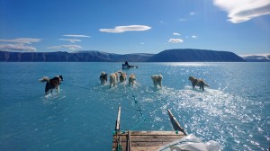
A Danish meteorological team travels across submerged sea ice in Greenland’s Inglefield Bredning fjord on June 13, 2019. Greenland lost sea ice at an alarming rate during the year. In July alone, the island lost more sea ice than it normally does in a year. Credit: Steffen M. Olsen, Danish Meteorological Institute

A Danish meteorological team travels across submerged sea ice in Greenland’s Inglefield Bredning fjord on June 13, 2019. The area is normally covered with ice and snow. Credit: Steffen M. Olsen, Danish Meteorological Institute

At the highest point of the Greenland Ice Sheet, 10,550 feet (3,216 meters) above sea level, temperatures topped freezing (32 °F or 0 °C) for more than 16 hours during July 30 and 31, melting some 12.5 billion tons (11.3 billion metric tons) of ice during that brief period. It was the first time ice had melted at that high point since July 2012, and it was just the third such ice melt there in the last 700 years.
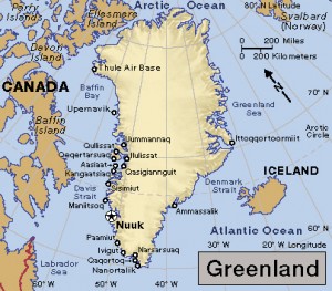
Click to view larger image Greenland.  Credit: WORLD BOOK map

Click to view larger image. Greenland, a self-governing territory of Denmark, stretches from the Arctic to the North Atlantic Ocean. Credit: WORLD BOOK map

The ice sheet that covers Greenland is about the size of Alaska, and it contains enough ice to raise global sea levels by more than 20 feet (6 meters). During an average summer, Greenland will lose some ice from meltwater and from icebergs that calve (break off) into the ocean. But the ice loss typically happens at the sheet’s edges at sea level—not at the highest and coldest points. The amount of ice loss is also normally much less. From 1981 to 2010, the average ice melt from July 30 to August 3 was 15 billion tons (13.6 billion metric tons).
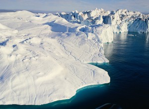
Huge icebergs form in the area shown in this photograph, where the Jakobshavn Glacier flows into the sea near Ilulissat, Greenland. Credit: © Radius Images, Getty Images

Huge icebergs form where the Jakobshavn Glacier flows into the sea near Ilulissat, Greenland. Credit: © Radius Images, Getty Images

The drastic summer ice melt in Greenland is a continuation of an alarming and worsening trend. In 1972, Landsat satellites (a project then known as the Earth Resources Technology Satellite) began photographing and mapping Greenland’s ice sheet. Landsat, a joint mission of NASA and the United States Geological Survey, uses a series of satellites to produce detailed images of Earth from space.

From 1979 to 2006, satellite images showed a 30 percent rise in the amount of Greenland ice that melts each summer, and the ice loss continues to increase. Greenland’s ice fronts have drastically retreated, rocky peaks have become exposed, and the size and shape of the island’s many fiords have changed significantly. In August 2019, Landsat images showed wet snow and melt ponds at Greenland’s higher elevations, and large parts of the island’s shrinking glaciers appeared brownish grey. The color indicates that the surface has melted, a process that concentrates dust and rock particles and leads to a darker recrystallized ice sheet surface.

Greenland is not the only site of rapidly increasing ice melt. Warmer global temperatures are reducing glaciers and ice fields in the Arctic and Antarctica, as well as in Iceland, the Alps, the Andes, the Himalaya, the Rockies, at Kilimanjaro in Tanzania, and in the Sudirman Range in Indonesia.


Tags: climate change, glacier, global warming, greenland, ice melt
Posted in Conservation, Current Events, Disasters, Environment, Government & Politics, Health, History, Natural Disasters, People, Science | Comments Off

More Bad News from Antarctica

Wednesday, December 3rd, 2014

December 3, 2014

The latest study of the West Antarctic Ice Sheet has provided more strong evidence of the devastating effect of global warming on this vulnerable region of Antarctica. The 21-year study found that the melting rate of the ice in the already-unstable Amundsen Sea region has tripled from 2003 to 2009. The findings, reported by scientists at the University of California, Irvine (UCI), and NASA’s Jet Propulsion Laboratory (JPL) in Pasadena, California, are being described as the most authoritative estimate of ice loss in the region.

A number of studies have revealed that the West Antarctic Ice Sheet, which contains Antarctica’s fastest flowing ice, is warming much faster than scientists had estimated and that melting there has accelerated significantly since the early 1990′s. In May 2014, scientists from UCI and JPL reported that glaciers around the Amundsen Sea, the weakest of the continent’s ice sheets, appear to have begun a gradual but “unstoppable” slide into the sea. For the new study, the UCI and JPL scientists compared measurements of the “mass balance” of glaciers flowing into the sea using four different tools, including Earth-orbiting satellites, radars, and lasers. NASA defines mass balance as a measure of how much ice the glaciers gain and lose over time from accumulating or melting snow, discharges of ice as icebergs, and other causes. The scientists found that from 1992 to 2003, the melting rate increased by 6.7 billion tons (6 billion metric tons) of ice each year. From 2003 to 2009, however, the melting rate soared to 18 billion tons (16 billion metric tons) annually. The scientists calculated that the region has shed an amount of ice equal to Mount Everest, the highest mountain in the world, every two years for the past 21 years.

The glaciers in Amundsen Sea region of West Antarctica are losing ice faster than any other glaciers on the continent. (NASA/Michael Studinger)

The West Antarctic Ice Sheet is especially vulnerable to climate change, in part, because most of the ice sheet lies on terrain that is an average of 3,300 feet (1,000 meters) below sea level. As a result, the leading edges, or tongues, of the glaciers float on seawater. When a glacier melts, its grounding line–the point where a glacier attaches to underlying terrain and begins to float–also retreats. Nearly all the melting takes place on the underside of a glacier beyond the grounding line, where the ice comes into contact with warm seawater.

Additional World Book articles:

  • Exploration (the Exploration of Antarctica)
  • Global warming (2009) (a Back in Time article)
  • The Great Meltdown (a special report)
  • Science in Antarctica (a special report)

Tags: amundsen sea, antarctica, glacier, global warming, west antarctic ice sheet
Posted in Current Events, Environment, Government & Politics, Science, Technology | Comments Off

Melting of West Antarctic Glaciers Appears “Unstoppable”

Tuesday, May 13th, 2014

May 13, 2014

A huge area of the West Antarctic Ice Sheet appears to have begun a gradual but “unstoppable” slide into the sea, according to two new studies. The findings are the first firm evidence that this section of the ice sheet, which currently poses the largest threat of rapid sea-level rise, is in an “irreversible decline.” The loss of ice there, scientists have warned, is the first step in a chain reaction that could contribute significantly to higher-than-predicted global sea levels over centuries. Moreover, said scientists involved in the research, the simulanteous retreat (shrinking) of ice over such a large area suggests that the process was triggered by a common cause, which they link, in part, to global warming.

The first study, by scientists from the University of California, Irvine, and NASA’s Jet Propulsion Laboratory, is based on 40 years of observations of six glaciers bordering the Amundsen Sea. Since 1973, the amount of ice released by the glaciers has risen 77 percent annually, an amount nearly equal to the ice entering the ocean each year from the entire Greenland Ice Sheet. The leading edges of these glaciers, called tongues or ice shelves, float on seawater. The point where a glacier loses contact with the underlying terrain and begins to float is called the grounding line. Nearly all the melting takes place on the underside of a glacier beyond this line, where the ice comes into contact with warm seawater.

The scientists found that the speed of the Amundsen Sea glaciers flowing downhill from the center of the ice sheet has increased over the past 40 years. In addition, the glaciers’ grounding lines have been retreating. This means that sections of the glaciers are now floating above places they used to touch. The grounding line for the Pine Island Glacier, for example, retreated by 19 miles (31 kilometers) between 1992 and 2011.

The second study involved advanced computer modeling of the Thwaites Glacier, one of the six glaciers in the NASA study. Scientists had thought this glacier would remain stable for thousands of years. However, said glaciologist Ian Joughin of the University of Washington, Seattle, “this glacier is really in the early stages of collapse.” Its grounding line retreated by nearly 9 miles (14 kilometers) from 1992 to 2011.

Glaciers in the NASA study appear in red. The darker the color, the faster the speed at which the glaciers are flowing toward the Admundsen Sea. (Image credit: Eric Rignot)

The retreat of a grounding line could be the first step in a chain reaction. In this process, as the line retreats, the glacier gets thinner. As the ice grows thinner, it offers less resistance to the water and flows faster. The glacier also loses its ability to hold back inland glaciers flowing toward the sea. These glaciers, in turn, grow thinner and flow faster. The result is more ice flowing into the sea and rising sea levels.

Scientists are still uncertain about the timeline for the collapse of the Amundsen Sea glaciers. The NASA scientists estimated that it could take as few as 200 or as many as 900 years for all the ice in the glaciers to melt. That meltwater would be enough to raise all sea levels by 4 feet (1.2 meters). According to a recent report by the United Nations Intergovernmental Panel on Climate Change, sea levels are projected to rise from 1 to 3 feet (26 to 98 centimeters) by 2100. However, most projections of sea-level rise do not take into account ice loss from West Antarctica. The findings from the new studies, the NASA scientists say, suggest that these projections should be revised upward.

Additional World Book articles:

  • Antarctica: The Hidden Continent (a Special Report)
  • Meltdown: Climate Change in the Arctic (a Special Report)
  • The Great Meltdown (a Special Report)


Tags: climate change, glacier, global warming, seal level, west antarctica
Posted in Current Events, Environment, Science, Technology | Comments Off

Glacier Is Racing to the Sea

Friday, May 9th, 2014

May 9, 2014

The biggest glacier (by size) in Europe is now draining into the Barents Sea at a rate 10 times as fast as it was just a few years ago, according to data collected by a new Earth-observation satellite. The glacier, the Austfonna icecap on Svalbard, had been relatively stable for some decades. (Icecaps are glaciers that cover an area of 19,300 square miles (50,000 square kilometers) or less. Larger glaciers are called ice sheets.) Svalbard is a group of islands in the Arctic Ocean, about midway between Norway and the North Pole. The Earth-observation satellite is the Sentinel-1A, an advanced radar satellite launched last month by the European Space Agency. Scientists with the Sentinel project described the change in the icecap’s speed as “extraordinary.” At this point, they are not certain whether the speed-up is the result of natural changes in the movement of the icecap or a sign of global warming in the Arctic.

The Austfonna icecap covers more than 3,000 square miles (8,000 square kilometers) of Nordaustlandet, the second-largest island in the Svalbard archipelago. Ice from the glacier drains into the sea mainly though a so-called outlet glacier along the southeastern coast of the island. An outlet glacier is a section of an icecap or ice sheet that moves faster than the ice around it.

The chief outlet glacier of the Austfonna icecap (shown in box) is flowing into the sea at least 10 times as fast as it was only a few years ago. (ESA/DLR/Gamma/University of Leeds/University of Edinburgh)

The melting of land-based glaciers is one of the two main causes of the 8-inch (210-millimeter) average rise in global sea levels that occurred between 1880 and 2009.  The other major cause is thermal expansion caused by the warming of the oceans (water expands as it warms). According to one expert involved with the project, icecaps and glaciers contain only 1 percent of the world’s ice. But they have contributed about 50 percent of modern sea-level rise due to ice melting. Glaciers flow slowly under the influence of gravity. If the amount of new snow that accummulates on the glacier is about the same as the amount of the glacier’s ice melting into the sea, the glacier is considered stable.

Additional World Book articles:

  • Ice formation
  • The Great Meltdown (a Special Report)

Tags: arctic, barents sea, glacier, global warming, icecap
Posted in Current Events, Environment | Comments Off

Life Found Under Antarctic Glacier

Tuesday, February 19th, 2013

February 19, 2013

Scientists announced this week that for the first time they had found living bacteria beneath a glacier in Antarctica. A team of scientists from the Whillans Ice Stream Subglacial Access Research Drilling (WISSARD), funded by the U.S. National Science Foundation, made the find. The bacteria were discovered in Lake Whillans, which is about one-half mile (800 meters) below the West Antarctic Ice Sheet. The lake is about 5-feet (1.5-meters) deep, and scientists had to drill through the entire half mile of ice to take a sample of the lake water. After running a culture of the sample, they were able to see the bacteria under a microscope. The bacteria are members of a new ecosystem of living things that is able to survive with little light, at very cold temperatures, and under large amounts of pressure.

Lake Whillans sits at the upper tip of the Ross Ice Shelf in West Antarctica. (World Book map; map data © MapQuest.com, Inc.)

DNA testing is required for scientists to be able to identify the bacteria. Once identification has occurred, it might give scientists a better idea of what the bacteria use as food.

In addition to the excitement of finding life under Antarctic ice, scientists were also very interested in the bacteria because the conditions in Lake Whillan are not unlike some of the terrains found in outer space. For example, Jupiter’s moon, Europa, and Saturn’s moon, Enceladus, both have water that exists under ice. If the bacteria discovered under Antarctica is, for example, found to consume minerals from surrounding rock as food, a similar lifeform might be able to exist elsewhere in the solar system.

Additional World Book articles:

  • Jupiter
  • Europa
  • Saturn
  • Enceladus

Tags: arctic, bacteria, dna, ecosystem, glacier, ice
Posted in Current Events, Education, Environment, Science, Space | Comments Off

Antarctica Melting Much Faster Than Believed

Friday, December 28th, 2012

December 28, 2012

The West Antarctic Ice Sheet is warming significantly faster than scientists had estimated, according to a study published in the journal Nature Geoscience. The authors of the study revealed that the average temperature at a research station in the middle of West Antarctica has risen by 4.3 Fahrenheit degrees (2.4 Celsius degrees) since 1958–roughly twice as much as scientists previously believed and three times the overall rate of global warming. Particularly surprising was the discovery that although most of the Antarctic warming took place as expected in the spring (September, October, and November in the Southern Hemisphere), some warming occurred in the summer (December, January, and February). Scientists had thought that temperatures in the Antarctic remained relatively stable during the summer.

This alarming report follows another recent study, which found that melting in West Antarctica has accelerated by about 50 percent since 1992. That study, published in November by 47 climate scientists from 26 labs around the world, also found that Greenland’s ice sheets are melting at a rate five times faster than they were in the 1990’s.

Ice and snow cover 98 percent of Antarctica, the world's coldest region. (© Rod Planck, Photo Researchers)

The West Antarctic Ice Sheet is the part of Antarctica that lies west of the Transantarctic Mountains and is mainly in the Western Hemisphere. Because of the enormous weight of the ice there, the terrain under the ice sheet is an average of 3,300 feet (1,000 meters) below sea level. At the ice sheet’s edge near the Southern Ocean, broad, flat, floating ice shelves fill several of Antarctica’s bays and channels. Those ice shelves, along with the ice in the interior, comprise about 90 percent of the world’s ice. Scientists have calculated that if all of Antarctica’s ice melted, Earth’s oceans would rise nearly 230 feet (70 meters), flooding coastal cities around the world. The November study of ice sheets in both polar regions found that the melting there has caused nearly a ½ inch (11 millimeters) rise in in sea level since 1992, or about 20 percent of the overall rise.

One of the scientists involved in the new study, Andrew J. Monaghan of the Colorado-based National Center for Atmospheric Research, noted “When you see this type of warming, I think it’s alarming.”

Additional World Book articles:

  • Exploration (the Exploration of Antarctica)
  • Glacier
  • Global warming (2009) (a Back in Time article)
  • The Great Meltdown (a special report)
  • Science in Antarctica (a special report)


Tags: climate change, glacier, global warming, greenland, ice sheet, west antarctica
Posted in Current Events, Environment, Science | Comments Off

Polar Ice Melting Much Faster Than Expected

Friday, November 30th, 2012

November 30, 2012

Greenland’s ice sheets are melting at a rate five times faster than they were in the 1990’s, according to a new study of polar ice sheets reported in the journal Science. The study, which involved 47 climate scientists from 26 labs around the world, also found that the melting in West Antarctica has accelerated by about 50 percent. The only ice sheet that shows no signs of melting is in East Antarctica, the highest and coldest area on the planet. That ice sheet is actually growing, because rising temperatures have increased snowfall. Warmer air holds more water, so higher temperatures typically increase snowfall in cold areas. However, the small increase in ice there is not enough to offset the loss of ice from West Antarctica. The melting is being caused by global warming—the gradual increase in average temperatures at Earth’s surface. Most climate scientists have concluded that global warming is caused mainly by greenhouse gases released by burning such fossil fuels as coal and oil.

The study found that the melting ice sheets have caused nearly ½ inch (11 millimeters) of the rise in sea level since 1992, or about 20 percent of the overall rise. The scientists cautioned that it is difficult to determine how quickly sea level may rise in the future, largely because of uncertainties about how quickly glaciers will flow into the sea. But there is no question that the rise in sea level has also accelerated. Most climate scientists expect sea level to rise by 3 to 6 feet (1 to 2 meters) by 2100.

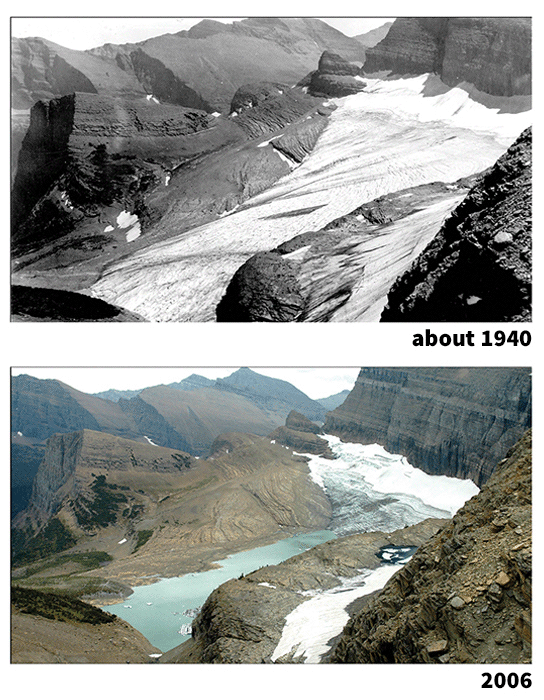
The retreat of a mountain glacier can provide visible evidence of global warming. These photographs show two late-summer views of Grinnell Glacier in Glacier National Park, Montana. In the photo taken around 1940, top, Upper Grinnell Lake had only begun to form at the glacier’s end. By 2006, bottom, melting ice had caused the lake to swell in size. Researchers predict that warming will melt all of the park’s glaciers by 2030. (Glacier National Park Archives, top; U.S. Geological Survey, photograph by Karen Holtzer, bottom.)

The new research provides more evidence that the Arctic is warming more quickly than any other area of the planet. In September, scientists at the National Snow and Ice Data Center reported the greatest melt of Arctic sea ice ever recorded. In fact, all six of the record-setting years for melting sea ice have occurred in the last six years. Melting sea ice does not add to rising sea level, because sea ice already floats on ocean water. But warming polar waters eat away at the edges of ice sheets on land, causing glaciers to flow into the ocean more quickly. Ice that melts from land does cause rising sea level.

The research helps to resolve scientific uncertainty about the rate of melting in the polar ice sheets. Different methods of measurement have found somewhat different rates of melting. The new research combined three different sources of data. The first was altimetry, which involves aircraft using lasers to measure the elevation of the ice sheet. Another source was satellites that measure ice using radar. The third source was satellites that measure tiny changes in Earth’s gravitational field. This field varies slightly depending on the mass of ice in a given location. Together, the three methods of measurement show the accelerating loss of polar ice.

Additional World Book articles:

  • Kyoto Protocol
  • Ice formation
  • Intergovernmental Panel on Climate Change
  • The Great Meltdown (a Special Report)
  • Global warming (2011) (a Back in Time article)
  • Global warming (2010) (a Back in Time article)

Tags: climate change, glacier, global warming, greenhouse effect, greenhouse gases, ice sheet, melting ice
Posted in Current Events, Environment, Science, Technology | Comments Off

“Grand Canyon of Antarctica” Discovered

Friday, July 27th, 2012

July , 2012

A huge canyon nearly as deep as the Grand Canyon has been discovered beneath a remote area of the West Antarctic ice sheet, a team of British scientists has reported. Scientists think that the canyon, which lies buried under nearly 1 mile (1.6 kilometers) of ice, may be a major reason for the dramatic loss of ice from West Antarctica over the past 20 years. The previously unknown canyon, named the Ferrigno Rift, lies beneath a massive glacier known as the Ferrigno Ice Stream, located just west of the Antarctic Peninsula. Satellite data collected over several decades has documented both a significant drop in the depth of the ice stream as well as an increase in the amount of ice breaking off into the Southern Ocean, which surrounds Antarctica. Scientists have calculated that melting ice from West Antarctica is responsible for nearly 10 percent of the current rise in global sea levels.

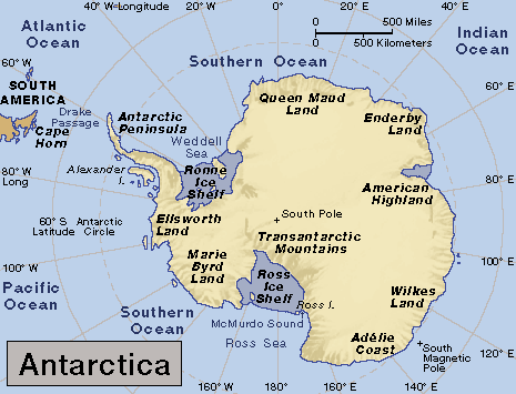
(World Book map; map data © MapQuest.com, Inc.)

The canyon was discovered by scientists from the University of Aberdeen in Scotland, who spent a brutal nine weeks measuring the topography of the ice stream’s rocky base using ice-penetrating radar devices hitched to snowmobiles. Glaciologist Robert Bingham of Aberdeen said that the dropoff in his measurements of the depth of the ice was so startling that he drove over the area two or three times to confirm his data.

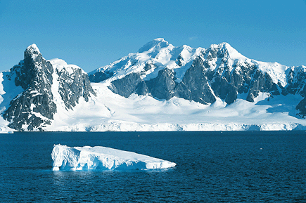
Antarctica's rugged coast features jagged mountain peaks and glacier-filled valleys. Ice and snow cover 98 percent of the continent. Antarctica is the world's coldest region. (© Rod Planck, Photo Researchers)

An analysis of the data by Bingham and colleagues from the British Antarctic Survey indicate that the Ferrigno Rift is about 6 miles (9.6 kilometers) wide and at least 62 miles (100 kilometers) long. The Grand Canyon is more than 1 mile deep, 277 miles (446 kilometers) long, and from less than 1 mile to 18 miles (29 kilometers) wide. Unlike the Grand Canyon, the Ferrigno Rift was created when sections of Earth’s crust in what is now West Antarctica separated, creating a valley. Erosion likely deepened the valley, which probably formed tens of millions of years ago when Antarctica was ice free. The Grand Canyon was created chiefly through erosion by the Colorado River.

Bingham reported that the rift may be speeding the movement of the Ferrigno Ice Stream to the sea in several ways. Glaciers move more quickly over sediments like those found near the bottom of the rift. In addition, water from the Southern Ocean, which appears to be warming faster than any other ocean, may be flowing into the rift, causing erosion of the glacier from below.

Additional World Book articles:

  • Global warming
  • Ice formation
  • Icecap
  • Science in Antarctica (a Special Report)
  • The Great Meltdown (a Special Report)


Tags: climate change, ferrigno rift, glacier, global warming, grand canyon, ice sheet, southern ocean, west antarctica
Posted in Current Events, Environment, Science, Technology | Comments Off

  • Most Popular Tags

    african americans ancient greece archaeology art australia barack obama baseball bashar al-assad basketball black history month china climate change conservation earthquake european union football france global warming iraq isis japan language monday literature major league baseball mars mexico monster monday mythic monday mythology nasa new york city nobel prize presidential election russia space space exploration syria syrian civil war Terrorism ukraine united kingdom united states vladimir putin women's history month world war ii