Behind the Headlines – World Book Student
  • Search

  • Archived Stories

    • Ancient People
    • Animals
    • Arts & Entertainment
    • Business & Industry
    • Civil rights
    • Conservation
    • Crime
    • Current Events
    • Current Events Game
    • Disasters
    • Economics
    • Education
    • Energy
    • Environment
    • Food
    • Government & Politics
    • Health
    • History
    • Holidays/Celebrations
    • Law
    • Lesson Plans
    • Literature
    • Medicine
    • Military
    • Military Conflict
    • Natural Disasters
    • People
    • Plants
    • Prehistoric Animals & Plants
    • Race Relations
    • Recreation & Sports
    • Religion
    • Science
    • Space
    • Technology
    • Terrorism
    • Weather
    • Women
    • Working Conditions
  • Archives by Date

Posts Tagged ‘southern ocean’

Exploring the Five Deeps

Friday, September 27th, 2019

September 27, 2019

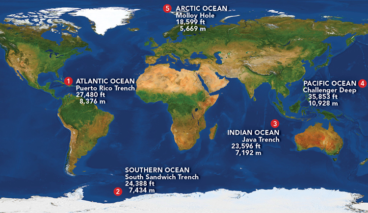
Last month, on August 24, the American undersea explorer Victor Vescovo reached the Molloy Deep (also known as the Molloy Hole), the deepest point—some 3.4 miles (5.5 kilometers) beneath the surface—of the Arctic Ocean. Upon completion of the dive, Vescovo became the first person to dive to the deepest parts of all five of the world’s oceans. Over the previous 10 months, Vescovo’s Five Deeps Expedition had reached the ultimate bottoms of the Atlantic, Southern, Indian, and Pacific oceans.

Victor Vescovo indicates to he Expedition Team the proposed routing for the South Sandwich. Credit: © The Five Deeps Expedition

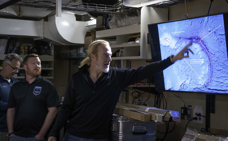
American explorer Victor Vescovo and the Five Deeps team discuss the South Sandwich Trench near Antarctica on Feb. 3, 2019. Credit: © The Five Deeps Expedition

Victor Vescovo was born in Dallas, Texas, in 1966. He developed a love of the ocean as a 20-year officer in the United States Navy Reserve. At the same time, he made a fortune as a private businessman. Vescovo’s taste for adventure pushed him to climb the highest peaks on each of the world’s continents—including Asia’s Mount Everest, the tallest mountain in the world. He has also skied to the North and South poles and is an airplane and helicopter pilot.

Click to view larger image Map of the five expeditions. Credit: WORLD BOOK illustration by Brenda Tropinski; © Best Backgrounds/Shutterstock

Click to view larger image
The Five Deeps Expedition reached the five deepest points of the world’s oceans. Credit: WORLD BOOK illustration by Brenda Tropinski; © Best Backgrounds/Shutterstock

Having conquered the world’s summits, Vescovo planned the Five Deeps Expedition to explore its depths. Vescovo and his company Caladan Oceanic put together a team of engineers, scientists, and experienced sea personnel. Caladan’s specially designed submersible, Limiting Factor, made the deep dives, supported by the surface vessel Pressure Drop. A submersible is an undersea vessel used for oceanographic research and exploration.

The mother ship "DSSV Pressure Drop" (background) and the dive boat "DSV Limiting Factor" during the expedition in the Indian Ocean. Credit: © The Five Deeps Expedition

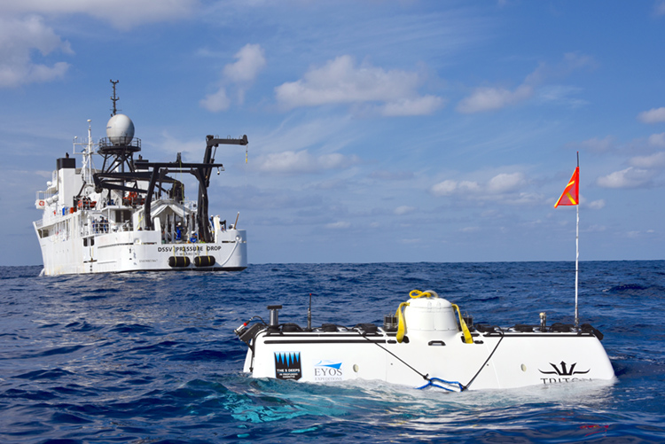
On April 2, 2019, the Five Deeps submersible Limiting Factor rests on the surface of the Indian Ocean behind the support ship Pressure Drop. Credit: © The Five Deeps Expedition

Five Deeps began in December 2018 at the Bronson Deep in the Puerto Rico Trench, the deepest point of the Atlantic Ocean. (A deep is an ocean area with a depth of more than 18,000 feet [5,490 meters]). Vescovo set an Atlantic record by diving alone in Limiting Factor to a depth of 27,480 feet (8,376 meters). (Mount Everest goes 29,035 feet [8,850 meters] in the other direction.) Two months later, in February 2019, Vescovo and his team took Pressure Drop near the coast of Antarctica above the South Sandwich Trench in the Southern Ocean. Vescovo then set a Southern Ocean record by diving solo to a depth of 24,390 feet (7,434 meters). (Determining exact depths can be tricky, but after the Five Deeps numbers are verified, they will slightly redefine the landscape of the world’s ocean bottoms.)

In April, Five Deeps headed to the Indian Ocean and the Java Trench (also called the Sunda Trench) near the Indonesian island of Sumatra. Vescovo took Limiting Factor to a depth of 23,596 feet (7,192 meters) in the Indian Ocean, and captured film of a new species of hadal snailfish (a type of sea snail) and other deep bottom-dwelling creatures. The crew then took Pressure Drop above Challenger Deep in the Mariana Trench, an underwater depression in the Pacific Ocean that is the deepest known spot in the world. There, in May, Vescovo set a record for the deepest ever dive, reaching 35,853 feet (10,927 meters) into Challenger Deep’s eastern pool. The previous depth record was set at Challenger Deep in 1960 by the U.S. Navy Lieutenant Don Walsh and the Swiss oceanographer Jacques Piccard, who dived 35,797 feet (10,911 meters) beneath the ocean surface in the bathyscaph (a special diving craft) Trieste. Vescovo discovered three new species of marine animals on his voyage to the bottom of Challenger Deep—along with pieces of plastic trash and other signs of pollution.

In 1960, Swiss explorer Jacques Piccard (center) descended into the Mariana Trench deep in the Pacific Ocean with Lieutenant Don Walsh (front) of the United States Navy in the Trieste, a deep-sea diving ship designed by Piccard. Credit: Steve Nicklas, NOS/NGS

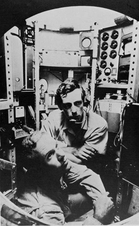
In 1960, Swiss explorer Jacques Piccard (center) descended into the Mariana Trench with Lieutenant Don Walsh (front) of the United States Navy. Credit: Steve Nicklas, NOS/NGS

The Five Deeps Expedition explored another Pacific deep point in June, diving 35,509 feet (10,823 meters) to the bottom of the Tonga Trench’s Horizon Deep. And then in early August, while traveling through the North Atlantic on the way to the Arctic, Five Deeps visited the watery grave of the ill-fated ocean liner Titanic, some 13,000 feet (4,000 meters) beneath the waves. A couple weeks later, the team reached the Molloy Trench off the coast of Norway, where Vescovo made the final dive. The Five Deeps Expedition, whose motto was In Profundo: Cognitio (Latin for In the Deeps: Knowledge), wrapped up in September.

The Five Deeps Expedition traveled more than 46,000 miles (74,000 kilometers), discovered several new species of marine animals, and mapped over 116,000 square miles (300,000 square kilometers) of sea floor. In addition to the piloted dives, the Five Deeps team deployed robotic deep-sea landers in several locations. The expedition also recorded over 500 hours of video that will be made into the Discovery Channel documentary series “Deep Planet,” scheduled to air in 2020.

Tags: arctic ocean, atlantic ocean, diving, five deeps expedition, indian ocean, jacques piccard, mariana trench, oceans, pacific ocean, sea exploration, southern ocean, submersible, victor vescovo
Posted in Conservation, Current Events, Environment, People, Science, Technology | Comments Off

Antarctic Glacier Spawns Chicago-Sized Iceberg

Thursday, July 11th, 2013

July 11, 2013

An iceberg slightly larger than the city of Chicago has finally calved (broken away) from Antarctica’s Pine Island Glacier (PIG), two years after scientists first spotted a 15-mile (24-kilometer) crack in the PIG’s ice shelf. (An ice shelf is the foreward part of an ice sheet that floats on water.) The PIG, located in West Antarctica, is shrinking faster than any other glacier on Earth. It also ranks number one among glaciers whose melting is contributing to the rise of global sea levels. The new iceberg, which has a surface area of 278 square miles (720 square kilometers), is now floating in the Amundsen Sea.

Scientists with NASA’s Operation IceBridge first noticed a crack in the PIG’s ice shelf in October 2011 while flying over and surveying the massive glacier. The crack, then about 15 miles (24 kilometers) long and 164 feet (50 meters) wide, had grown to 17 miles (28 kilometers) long and 1,770 feet (540 meters) at its widest point just before the iceberg split off, according to scientists at the Alfred Wegener Institute for Polar and Marine Research in Bremerhaven, Germany. Scientists at the institute have been tracking the birth of the iceberg using the German Space Agency’s TerraSAR-X satellite.

The new iceberg that calved from the Pine Island Glacier appears in a satellite image from the German Space Agency on 8 July 2013. (DLR)

Calving is a natural process for Antarctic ice sheets and is not necessarily related to global warming. The PIG produced huge icebergs in 2001 and 2007. However, scientists have found that the PIG has grown significantly thinner and has begun to move faster toward the sea in recent decades. The glacier is currently responsible for about 10 percent of all the ice flowing into the sea from West Antarctica.

The new iceberg, however, did not set any records for size. In March 2000, one of the largest icebergs ever recorded separated from the Ross Ice Shelf. Named B-15, it was around 4,250 square miles (11,000 square kilometers) in surface area—about the size of the island of Jamaica—and possibly more than 1,000 feet (300 meters) thick. Even after drifting into the warmer waters of the Southern Ocean and breaking apart, some pieces survived more than 10 years. In January 2005, a huge chunk of B-15 ran aground in Antarctica’s McMurdo Sound in the Ross Sea, devastating Adélie penguin colonies. The iceberg prevented adult Adélie penguins from feeding in normally open waters. Many penguin chicks died of starvation while their parents trudged across the vast ice sheet in search of food.

Additional World Book articles:

  • Amundsen, Roald
  • Ice formation
  • Ross Dependency
  • The Great Meltdown (a special report)
  • Science in Antarctica (a special report)


Tags: calving, iceberg, southern ocean, west antarctica
Posted in Animals, Current Events, Environment | Comments Off

“Grand Canyon of Antarctica” Discovered

Friday, July 27th, 2012

July , 2012

A huge canyon nearly as deep as the Grand Canyon has been discovered beneath a remote area of the West Antarctic ice sheet, a team of British scientists has reported. Scientists think that the canyon, which lies buried under nearly 1 mile (1.6 kilometers) of ice, may be a major reason for the dramatic loss of ice from West Antarctica over the past 20 years. The previously unknown canyon, named the Ferrigno Rift, lies beneath a massive glacier known as the Ferrigno Ice Stream, located just west of the Antarctic Peninsula. Satellite data collected over several decades has documented both a significant drop in the depth of the ice stream as well as an increase in the amount of ice breaking off into the Southern Ocean, which surrounds Antarctica. Scientists have calculated that melting ice from West Antarctica is responsible for nearly 10 percent of the current rise in global sea levels.

(World Book map; map data © MapQuest.com, Inc.)

The canyon was discovered by scientists from the University of Aberdeen in Scotland, who spent a brutal nine weeks measuring the topography of the ice stream’s rocky base using ice-penetrating radar devices hitched to snowmobiles. Glaciologist Robert Bingham of Aberdeen said that the dropoff in his measurements of the depth of the ice was so startling that he drove over the area two or three times to confirm his data.

Antarctica's rugged coast features jagged mountain peaks and glacier-filled valleys. Ice and snow cover 98 percent of the continent. Antarctica is the world's coldest region. (© Rod Planck, Photo Researchers)

An analysis of the data by Bingham and colleagues from the British Antarctic Survey indicate that the Ferrigno Rift is about 6 miles (9.6 kilometers) wide and at least 62 miles (100 kilometers) long. The Grand Canyon is more than 1 mile deep, 277 miles (446 kilometers) long, and from less than 1 mile to 18 miles (29 kilometers) wide. Unlike the Grand Canyon, the Ferrigno Rift was created when sections of Earth’s crust in what is now West Antarctica separated, creating a valley. Erosion likely deepened the valley, which probably formed tens of millions of years ago when Antarctica was ice free. The Grand Canyon was created chiefly through erosion by the Colorado River.

Bingham reported that the rift may be speeding the movement of the Ferrigno Ice Stream to the sea in several ways. Glaciers move more quickly over sediments like those found near the bottom of the rift. In addition, water from the Southern Ocean, which appears to be warming faster than any other ocean, may be flowing into the rift, causing erosion of the glacier from below.

Additional World Book articles:

  • Global warming
  • Ice formation
  • Icecap
  • Science in Antarctica (a Special Report)
  • The Great Meltdown (a Special Report)


Tags: climate change, ferrigno rift, glacier, global warming, grand canyon, ice sheet, southern ocean, west antarctica
Posted in Current Events, Environment, Science, Technology | Comments Off

  • Most Popular Tags

    african americans ancient greece animals archaeology art australia barack obama baseball bashar al-assad basketball china climate change conservation earthquake european union football france global warming iraq isis japan language monday literature major league baseball mars mexico monster monday mythic monday mythology nasa new york city nobel prize presidential election russia soccer space space exploration syria syrian civil war Terrorism ukraine united kingdom united states vladimir putin world war ii