Devastating Earthquake Jolts Turkey and Syria
Friday, February 10th, 2023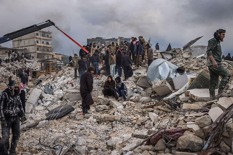
Civilians and rescue teams in Harem, Syria, search for survivors underneath rubble after a devastating earthquake hit the region on February 6, 2023.
Credit: © Anas Alkharboutli, dpa picture alliance/Alamy Images
On Monday, February 6th, 2023, a magnitude 7.8 earthquake hit Turkey at 4:17 AM. The epicenter of the earthquake hit Gaziantep in southeastern Turkey, close to the Syrian border. Tens of thousands of people died in the destruction, and the death toll continues to rise. The earthquake’s grasp extended to Syria, causing widespread damage in the northwestern region of the country. The earthquake and aftershocks were felt in Cyprus, Egypt, Israel, and Lebanon. The damage unfolds a new humanitarian crisis in a region already shaken by economic struggles, an ongoing refugee crisis, and war.
Turkey lies on crisscrossed fault lines resulting in frequent earthquakes. The United States Geological Survey reported the epicenter of the earthquake struck 20 miles (33 kilometers) from Gaziantep, Turkey. It hit 11 miles (17.7 kilometers) below the surface. Normally the initial shock of the earthquake hits hundreds of miles from the surface. The earthquake resulted in unusually strong aftershocks, including a 7.5 magnitude tremor 59 miles (95 kilometers) from the epicenter that was originally thought to be a second earthquake. Seismologists normally expect a 6.8 or lower magnitude aftershock from a 7.5 magnitude earthquake. The area has experienced more than 80 aftershocks measuring 4.0 magnitude and higher in the hours following the original quake. The earthquake was as powerful as the strongest earthquake on record in Turkey which occurred in 1939. The aftermath of the quakes has caused more damage than the country has seen in decades.
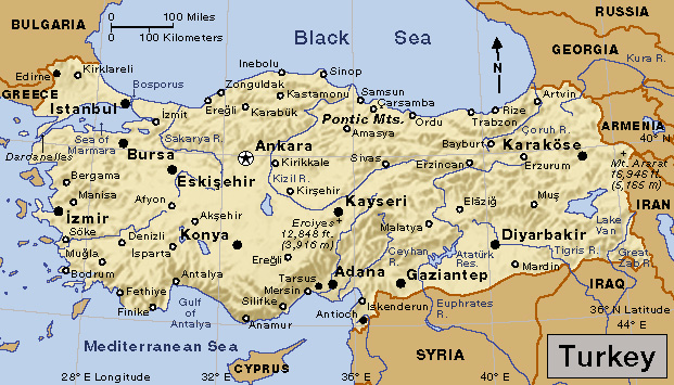
Turkey
credit: World Book map
President of Turkey Recep Tayyip Erdogan announced thousands of buildings collapsed in 14 different cities. As search and rescue teams look for people underneath the rubble, snow, rain, and low temperatures hinder their efforts. The near-freezing temperatures shorten the amount of time rescue teams have to retrieve people from the rubble. The weather hampers efforts to stay warm in other parts of the region. Many buildings in Turkey are older with concrete frames that cannot withstand strong tremors. Nearly 15 hospitals buckled from the earthquake. A 2,000-year-old castle used by the Romans and Byzantines also faced damage in the aftermath. The damage has cut power and gas in some regions, leading officials to wonder how to keep survivors warm and safe. Disaster relief officials reported nearly 6,400 people had been rescued already. President Erdogan declared seven days of national mourning.
According to the United Nations refugee agency, Turkey hosts 3.6 million Syrian refugees due to the 12-year civil war in Syria. Many people lived in temporary or unsafe housing before the earthquake struck. These camps and makeshift shelters were decimated by the quake. While many Turkish residents lost their homes, work, and schools, the refugee crisis broadens. As the region grapples with the chaos, the refugee crisis will continue.
More than 1,250 people have died, and 1,040 were injured in government-held Syria. These numbers do not account for Idlib, where rebels control the government in northwestern Syria. Officials estimate nearly 390 people have died in Idlib with hundreds more buried under rubble. Years of air strikes and bombardments weakened the infrastructure across Syria. The earthquake demolished several hospitals and pivotal infrastructure, further stressing underfunded and busy health centers.
Dozens of countries, the European Union, and the United Nations have offered aid and support for the affected regions. Search and rescue teams, aircraft, and medical teams are heading toward the region from all across the world. The earthquake is the deadliest earthquake the world has seen since the quake that killed 1,000 people in Afghanistan in June 2022.