Behind the Headlines – World Book Student
  • Search

  • Archived Stories

    • Ancient People
    • Animals
    • Arts & Entertainment
    • Business & Industry
    • Civil rights
    • Conservation
    • Crime
    • Current Events
    • Current Events Game
    • Disasters
    • Economics
    • Education
    • Energy
    • Environment
    • Food
    • Government & Politics
    • Health
    • History
    • Holidays/Celebrations
    • Law
    • Lesson Plans
    • Literature
    • Medicine
    • Military
    • Military Conflict
    • Natural Disasters
    • People
    • Plants
    • Prehistoric Animals & Plants
    • Race Relations
    • Recreation & Sports
    • Religion
    • Science
    • Space
    • Technology
    • Terrorism
    • Weather
    • Women
    • Working Conditions
  • Archives by Date

Posts Tagged ‘geology’

How Many Moonlets to a Moon?

Friday, February 3rd, 2017

February 3, 2017

One of the greatest questions in the formation of the solar system is in our own planetary back yard: how was the moon made? The current hypothesis (proposed explanation)—that the moon formed from chunks of Earth unloosed in a massive collision—has held sway among planetary scientists for over 30 years. But as more is learned about the moon, scientists are exploring other possibilities, and three scientists in particular—Raluca Rufu and Oded Aharonson of the Weizmann Institute of Science, Israel, and Hagai B. Perets of the Technion Israel Institute of Technology—are offering a different explanation. They published their new theory last month in the journal Nature Geoscience.

Entire globe of Moon showing rays. Credit: Lunar and Planetary Institute

A new theory suggests that the moon may have formed from debris unloosed by many small impacts on Earth rather than one big one. Credit: Lunar and Planetary Institute

Since the early days of astronomy, people have speculated on how the moon was formed. In the 1800’s, astronomers used to think that the moon split from Earth—but in a very peculiar way. The accepted hypothesis of that era said that in the distant past Earth spun so rapidly that a portion of it tore away, forming the moon and leaving behind a basin that became the Pacific Ocean. Scientists now know that plate tectonics formed the Pacific Ocean over hundreds of millions of years, and that Earth lacks the rotational speed to create such a spectacular split. In recent years, engineers have developed powerful computers that allow geologists to take new and closer looks at rocks returned from the Apollo moon landings from 1969 to 1972.

Artist Rendering earth hitting an object. The Moon may have been formed by a collision between Earth and an object that was strikingly similar in composition to our own planet. (Credit: NASA/JPL-Caltech)

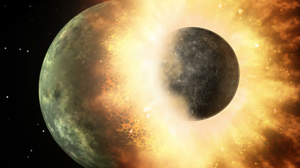
This artist rendering depicts the “Big Whack” hypothesis of Earth colliding with a planetary body. The resulting dust and debris from Earth would then have created the moon. (Credit: NASA/JPL-Caltech)

Since the 1980’s, one hypothesis has stood up best to scrutiny: that the moon formed as a result of a massive collision known as the Giant Impact or the “Big Whack.” According to this idea, a Mars-sized object collided with Earth about 4.6 billion years ago. As a result of the impact, a huge cloud of vaporized rock shot off Earth’s surface and went into orbit around Earth. The cloud cooled and condensed into a ring of small, solid bodies, which then gathered together, forming the moon.

If the Big Whack is favored, why are Rufu, Aharonson, and Perets exploring alternative ideas? The Big Whack explains many of the orbital and rotational characteristics of both Earth and the moon, but the hypothesis must be tweaked to an uncomfortable degree to account for the remarkable similarity of Earth rocks to moon rocks. The giant impactor would have had to have struck Earth in an extremely precise way to produce a moon with the makeup shown by returned lunar samples.

Therefore, the Israeli team started from scratch. They reasoned that because impacts were common in the early solar system, Earth should have been hit with objects large enough to create moons many times, not just once. They ran hundreds of computer simulations and found that a series of smaller impacts over the course of millions of years could explain the compositional similarity of Earth and its moon. A smaller body (more the size of the dwarf planet Ceres) would slam into Earth, forming a disk of debris that would eventually come together to form a moonlet, or mini-moon. Later, another body would collide with Earth, creating a new debris disk and another moonlet. Eventually, these moonlets would merge with one another. To reach the size of the current moon, a number of such collisions and moonlet creations and mergings (their guess was roughly 20) would be needed.

The new study is intriguing, but it does not disqualify the Giant Impact Hypothesis just yet. Rufu and her colleagues admit that much more research needs to be done to confirm their findings. For instance, the group did not determine if some of the moonlets could have been sucked back into Earth or flung out into the solar system. This would increase the number of impacts needed to make our moon, making this explanation less likely than a precise Giant Impact.

Tags: astronomy, earth, geology, moon
Posted in Current Events, History, Science, Space | Comments Off

Breaking Plates: New Boundary in Indian Ocean

Thursday, October 18th, 2012

October 18, 2012

Two powerful earthquakes that jolted the floor of the Indian Ocean off the Indonesian island of Sumatra in April 2012 have given scientists an unprecedented opportunity to study a tectonic plate being torn in two. Tectonic plates are vast, irregularly shaped sections of Earth’s rocky outer shell that are in contant motion with respect to one another. In three analyses, international teams of scientists have described how the magnitude 8.6 and 8.2 quakes advanced a multimillion-year split in the Indian-Australian Plate and the birth of a new tectonic boundary. The Indian-Australian Plate includes the countries of Australia and India and the Indian Ocean.

Earth’s rocky outer shell consists of huge slabs called tectonic plates. Many plates include both ocean floor and dry land. The plates slowly move with respect to one another. They spread apart at divergent boundaries, move toward each other at convergent boundaries, and grind past one another at transform boundaries. (World Book map)

The scientists reported that the magnitude 8.6 earthquake opened at least four major seafloor faults (cracks in Earth’s surface) running for several hundred miles (kilometers) in only 2 minutes and 40 seconds. The sides of these faults slipped between 20 to 120 feet (6 to 37 meters) past each other. In some cases, the earthquake turned corners, creating a bizarre gridlike pattern of cracks in the seafloor. The scientists also discovered that a highly unusual number of aftershocks of magnitude 5 or above occurred in the six days following the quakes. Some were felt as far away as the western coast of North America.

Information from a global network of seismographs had told scientists almost immediately that the magnitude 8.6 quake, which occurred about two hours before the 8.2 quake, was the most powerful strike-slip quake ever recorded. During a strike-slip earthquake, blocks of rock slide past each other horizontally. The Sumatra temblors were also highly unusual because they occurred in the middle of a plate. Strike-slip quakes generally occur at the boundary between two plates, such as along the San Andreas Fault in California.

The San Andreas Fault, like the newly created faults in the Indian Ocean, is a strike-slip fault, a surface fracture where two blocks of rock are sliding past one another horizontally. (© Craig Aurness, Corbis)

The Indian-Australian Plate is breaking up because of tensions between its eastern and western sections. The eastern section, which includes India, is being thrust under the Eurasian Plate to the north. This action, which began tens of millions of years ago, pushed up the Himalaya. Meanwhile, the plate’s western section, which includes Australia, has continued to move to the northeast. From time to time, the tensions cause parts of the plate to suddenly slip past one another.

Two previous earthquakes in the area–a 2004 quake that produced a devastating tsunami in the Indian Ocean and another in 2005–probably put additional stress on the area of the plate that ruptured in April, the scientists reported. The recent quakes did not produce a tsunami because the sideways motion of a strike-slip quake does not cause the up-and-down movement of ocean water that powers the deadly waves. The scientists noted that the final breakup of the plate will occur only after millions of years and several thousand more earthquakes.

Additional World Book articles:

  • Haitian earthquake of 2010
  • When the Earth Moves (a Special Report)
  • Geology (2005) (a Back in Time article)


Tags: earthquake, geology, indian ocean, plate boundary, plate tectonics, seismograph
Posted in Current Events, Natural Disasters, Science | Comments Off

Millions in the Central United States Join in Earthquake Drills

Tuesday, February 7th, 2012

Feb. 7, 2012

More than 2 million people in nine states planned to participate in the second Great Central United States ShakeOut on Feb. 7, 2012, the 200th anniversary of the last of at least three major earthquakes that struck the New Madrid fault in southern Illinois in late 1811 and early 1812. The earthquakes were the largest to strike the United States since the arrival of European settlers in North America. A shakeout is a drill designed to help teach people in seismic zones how to prepare for an earthquake and how to protect themselves when an earthquake occurs. A seismic zone is an area on the surface that is or could be affected by shifts in interconnected faults (fractures) in Earth’s lithosphere (crust and upper portion of the mantle). Drills based on the slogan “Drop, Cover and Hold On” were planned in states in and around the New Madrid Seismic Zone (NMSZ), including Alabama, Arkansas, Illinois, Kentucky, Mississippi, Missouri, Oklahoma, and Tennessee. The slogan reminds people to “Drop” to the floor, take “Cover” under a sturdy piece of furniture, and “Hold On” until the shaking stops.

The New Madrid quakes, all of which had an estimated moment magnitude of at least 7.5, affected an area about 10 times as large as that affected by the stronger San Francisco earthquake of 1906 and Haiti earthquake of 2010. The first quake, which took place on Dec. 16, 1811, was widely felt across the Eastern United States. The shaking woke people in New York City and Washington, D.C., and rang bells in Boston. The second quake occurred on Jan. 23, 1812. The third quake, which may have been the most violent of the three, destroyed the town of New Madrid and damaged many buildings in Saint Louis. Large waves called seiches swept northward in the Mississippi River, giving the impression that the river was flowing backwards. The death toll from the New Madrid quakes is unknown. However, if any deaths occurred, the number was probably very small. The  population of the area at that time included only about 100,000 non-Indians and a somewhat greater number of Indians. St. Louis had an estimated population of 5,700 in 1811. A major earthquake along the New Madrid fault today could affect about 40 million people, 12 million of whom live in the NMSZ itself.

An earthquake occurs when Earth's rock suddenly breaks and shifts, releasing energy in vibrations called seismic waves. The point on Earth where the rock first breaks is called the focus. The point on the surface above is known as the epicenter. World Book illustration

The NMSZ remains an area of high earthquake activity. It is, in fact, the most active seismic area in the United States east of the Rocky Mountains. According to the United States Geological Survey (USGS), large earthquakes in this zone could be more devastating than those in California for a number of reasons. Because of the nature of the crust in the Midwestern United States, shaking from an earthquake would travel farther. The region also has many buildings that have not been built or reinforced to limit earthquake damage. In addition, most people in the region are unprepared to cope with a major earthquake. A recent study estimated that a magnitude-7.7 quake along the New Madrid fault would cause 3,500 deaths and 80,000 injuries as well as the displacement of at least 2 million people in the NMSZ alone. The USGS has estimated that there is a 7 to 10 percent chance that a major NMSZ earthquake (7.5 to 8.0 magnitude) could occur in any 50-year period.

Additional World Book articles:

  • Geology
  • Plate tectonics
  • Richter magnitude
  • San Andreas Fault
  • When the Earth Moves (a Special Report)


Tags: drill, earthquake, geology, madrid fault, st. louis
Posted in Current Events, Government & Politics, Science | Comments Off

  • Most Popular Tags

    african americans ancient greece archaeology art australia barack obama baseball bashar al-assad basketball black history month china climate change conservation earthquake european union football france global warming iraq isis japan language monday literature major league baseball mars mexico monster monday mythic monday mythology nasa new york city nobel prize presidential election russia space space exploration syria syrian civil war Terrorism ukraine united kingdom united states vladimir putin women's history month world war ii