Irma’s Heavy Impact
Wednesday, September 13th, 2017September 13, 2017
Last week, on September 6, the massive storm known as Hurricane Irma began ravaging the Leeward Islands of the eastern Caribbean Sea. The storm then roared over Puerto Rico and Cuba before reaching southern Florida on September 10. The storm has since weakened to a tropical depression and dissipated over land, but it continues to bring torrential rains as it passes up the southeastern coast of the United States. Irma’s week of havoc has killed 70 people, leaving a shattered landscape and record flooding in its wake.
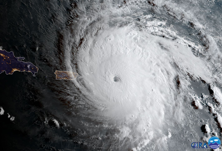
The eye of Hurricane Irma centers on the island of Anguilla on Sept. 6, 2017. Emergency precautions on Puerto Rico and the Dominican Republic (at left) prepared residents for the approaching storm. Credit: CIRA/NOAA
Hurricanes are measured using the Saffir-Simpson scale of intensity. The scale is based on wind speed and the height of the resulting storm surge—that is, how much the sea level rises above normal high tide. The scale ranges from Category 1 (weak) to Category 5 (devastating). Irma formed as a low pressure and thunderstorm system over the Atlantic Ocean before consolidating into a massive storm in the eastern Caribbean Sea. As a Category 5 hurricane, Irma devastated parts of Antigua and Barbuda, the islands of Anguilla, St.-Barthélemy, and St.-Martin, and the British and U.S. Virgin Islands. Irma’s strength fluctuated as it roared over Puerto Rico, the Dominican Republic, Haiti, Cuba, the Turcs and Caicos Islands, and the Bahamas, alternating between categories 3 and 4 before reaching the Florida Keys. The storm weakened to a tropical storm over Florida, but still caused massive wind and water damage. Among the Caribbean Islands, Irma killed 43 people. Twenty-seven more people have died in the southeastern U.S. states of Florida, Georgia, and South Carolina. Those numbers will very likely rise.
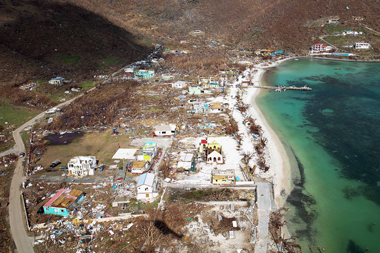
On Sept. 11, 2017, the flattened devastation of Jost Van Dyke island in the British Virgin Islands reveals the destructive force of Hurricane Irma. Credit: UK Department for International Development (licensed under CC BY 2.0)
In the southeastern United States and the Caribbean, hundreds of roads are still blocked by high water, and many airports, schools, and office buildings remain closed. Millions of people have been displaced, and many areas are without electric power or drinking water. Humanitarian and military aid is arriving in the areas hit by Irma, providing shelter, medicine, and food and water, and helping with the beginning of a colossal cleanup. Damage from Irma is expected to top $200 billion, and repairs and reconstruction after the storm could take years. Irma is the strongest storm to hit the region since Hurricane Wilma in 2005.
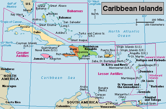
Click to view larger image
Hurricane Irma roared from east to west through the Caribbean Islands. Credit: WORLD BOOK map
Irma followed closely on the heels of Hurricane Harvey, which flooded the Texas coast, and preceded the formation of Hurricane Katia, which hit southern Mexico last weekend. An astounding fourth hurricane, Jose, chased Irma into the Caribbean before spinning off into the western Atlantic Ocean. Water temperatures in the Atlantic and Caribbean Sea are well above average, and massive storms feed off those warm waters. The expansion of high pressure areas—as well as a superabundance of moisture in the air—are ripe conditions for hurricane creation. They are also consistent with the effects of anthropogenic (human-caused) climate change.