Behind the Headlines – World Book Student
  • Search

  • Archived Stories

    • Ancient People
    • Animals
    • Arts & Entertainment
    • Business & Industry
    • Civil rights
    • Conservation
    • Crime
    • Current Events
    • Current Events Game
    • Disasters
    • Economics
    • Education
    • Energy
    • Environment
    • Food
    • Government & Politics
    • Health
    • History
    • Holidays/Celebrations
    • Law
    • Lesson Plans
    • Literature
    • Medicine
    • Military
    • Military Conflict
    • Natural Disasters
    • People
    • Plants
    • Prehistoric Animals & Plants
    • Race Relations
    • Recreation & Sports
    • Religion
    • Science
    • Space
    • Technology
    • Terrorism
    • Weather
    • Women
    • Working Conditions
  • Archives by Date

Posts Tagged ‘earthquake’

« Older Entries
Newer Entries »

Major Quake Hits Chile

Wednesday, April 2nd, 2014

April 2, 2014

A magnitude-8.2 earthquake slammed northern Chile last night, setting off a tsunami that forced tens of thousands of people to evacuate the country’s 2,650-mile- (4,260-kilometer-) long coastline. Waves as high as 6 feet (2.1 meters) were reported in some areas as well as along the Peruvian coast. The coasts of Peru, Ecuador, Colombia, Panama, Costa Rica, and Nicaragua were put on alert, and an advisory was issued for Hawaii. However, no major damage was reported. Electric power failed across much of Arica, a port city of about 200,000 people. The death toll across the region remains uncertain.

The quake was felt as far away as Bolivia’s capital, La Paz, some 300 miles (480 kilometers) from the earthquake’s epicenter off the coast near the Chilean copper mining city of Iquique, which is also a major port. During an evacuation in that city, some 300 prisoners escaped from a woman’s prison.
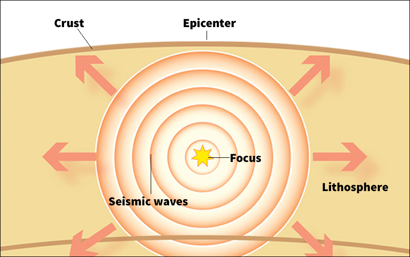
An earthquake occurs when Earth’s rock suddenly breaks and shifts, releasing energy in vibrations called seismic waves. The point on Earth where the rock first breaks is called the focus. The point on the surface above is known as the epicenter. (World Book illustration)
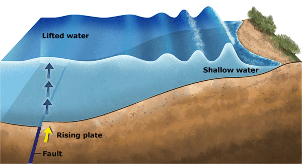
A tsunami can occur when an underwater earthquake displaces a large part of the sea floor. In this illustration, a tsunami wave spreads from a fast-rising section of ocean floor. The rising plate lifts the water above it, raising a hump of water that quickly ripples outward. As the ripple enters shallow water, it slows and grows in height. (World Book illustration by Matt Carrington)

Chile lies in one of the world’s most earthquake-prone zones. In 2010, a magnitude-8.8 earthquake off the coast of central Chile left more than 500 people dead. In 1960, a magnitude-9.5 earthquake hit off Chile’s coast near the city of Valdivia. More than 1,600 people were killed, largely from a subsequent tsunami. Seismologists believe the 1960 quake was the largest of the 20th century.

Additional World Book articles:

  • Plate tectonics
  • Big Waves: Tracking Deadly Tsunamis (a special report)
  • When the Earth Moves (a special report)
  • Chile 1960 (a Back in Time article)
  • Chile 2010 (a Back in Time article)
Tags: chile, earthquake, tsunami
Posted in Current Events, Natural Disasters, Science, Weather | Comments Off

Fire and Ice in Antarctica

Monday, December 2nd, 2013

December 2, 2013

Hundreds of earthquake tremors recorded by scientists in Antarctica have rocked the geological world by producing evidence of the first active volcano found so far inland on that frozen continent. Numerous volcanoes, both active and extinct, have been found along the Antarctic coastline and on nearby islands.

The earthquake swarms originated about 15 to 25 miles (25 to 40 kilometers) below the surface, near the Executive Committee Range in the Marie Byrd Land region of West Antarctica. The ice in that region is about 0.5-mile (0.8 kilometer) thick. The scientists, led by researchers from Washington University in St. Louis, stressed that they did not detect an actual eruption. Instead, the tremors likely resulted from the fracturing of rock as flowing magma and fluids opened new channels within the volcano. The tremors occurred beneath a 3,200-foot- (1,000-meter-) tall bulge under the ice that may be the cone (peak) of a volcano that formed sometime in the past as lava erupted from the volcano’s vent (opening).

The scientists detected the tremors while towing seismic equipment across the icy surface in 2010 and 2011 to map the structure of Earth’s mantle, the layer between inner core and outer crust. The seismic vibrations the scientists detected in Antarctica were nearly identical to so-called deep, long-period earthquakes (DLP’s) that have been detected beneath volcanoes in Alaska and Washington state. Although DLP’s sometime precede eruptions, scientists do not know if the tremors in Antarctica are signs that an eruption will occur there in the near future.

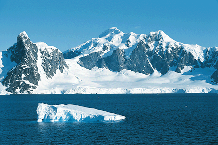
Volcanoes are common in Antarctica. Some are active, and others are hidden beneath the ice. But most of the known volcanoes are along the coastlines of the continent. © Rod Planck, Photo Researchers

If the volcano was to erupt, some of the ice above the vent would certainly melt, producing millions of gallons (liters) of water. Such a massive infusion of meltwater would speed of flow of nearby ice streams (slowly flowing “rivers” of ice within ice sheets). But unless the eruption was historically massive, it almost certainly would not melt all of the ice above. Scientists stressed that the greatest threat to Antarctica is still climate change. The Pine Island Glacier in West Antarctica, for example, is shrinking faster than any other glacier on Earth. It also ranks number one among glaciers whose melting is contributing to the rise of global sea levels.

Additional World Book articles:

  • Science in Antarctica
  • The Great Meldown


Tags: climate change, earthquake, global warming, seismology, tremors, volcano
Posted in Current Events, Environment, Science | Comments Off

Massive Earthquake Hits Southwest Pakistan

Wednesday, September 25th, 2013

September 25, 2013

A 7.7-magnitude earthquake struck southwest Pakistan’s Balochistan province yesterday. At least 325 people are known to be dead from collapsed buildings, and there are reports of hundreds of people wounded and many others trapped under rubble. The quake’s focus occurred at a depth of 13 miles (20 kilometers). The earthquake caused an island to appear in the Arabian Sea a little more than 1/2 mile (1 kilometer) off the coast near the port of Gwadar. The quake was so powerful that the it was felt across Pakistan; in Hyderabad, India; and in India’s capital, New Delhi. In Pakistan’s commercial center, Karachi, some 390 miles (680 kilometers) from the quake’s epicenter, office workers were forced to evacuate shaking buildings.

An earthquake occurs when Earth's rock suddenly breaks and shifts, releasing energy in vibrations called seismic waves. The point on Earth where the rock first breaks is called the focus. The point on the surface above is known as the epicenter (World Book illustration).

Additional World Book articles:

  • When the Earth Moves (a special report)
  • Pakistan 2005 (a Back in Time article)

Tags: earthquake, pakistan
Posted in Current Events, Environment, Natural Disasters | Comments Off

Radiation Levels at Fukushima Hit Lethal High

Wednesday, September 4th, 2013

September 4, 2013

Radiation levels around tanks in which contaminated water is stored at Japan’s crippled Fukushima nuclear power plant have risen to a new high. Ground readings near one set of tanks hit 2,200 millisieverts (mSv) yesterday, up from 1,800 mSv on August 31. (The sievert is the International System of Units [SI] unit that measures the dosage of absorbed radiation that produces biological effect.) Nuclear scientists believe that the 2,200 mSV reading is high enough to provide a lethal radiation dose within hours of exposure.

Tokyo Electric Power Company, which operates the plant, reported in early August that highly contaminated water was leaking from a storage tank. Other leaks have since been reported. Yesterday, the Japanese government announced that it would spend $473 million to build a wall of frozen earth around the damaged nuclear reactors using pipes filled with coolant.

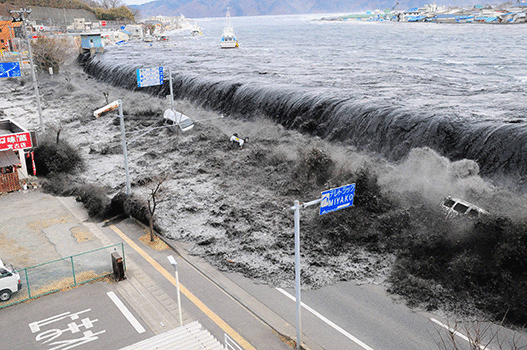
A huge wave strikes Japan's coast on March 11, 2011. An earthquake that day caused a tsunami (series of powerful ocean waves) that caused widespread destruction on Honshu, Japan's largest island (Mainichi Shimbun, Reuters).

A massive earthquake and subsequent tsunami in March 2011 damaged the cooling systems to three Fukushima plant reactors, which went into meltdown. To cool these reactors, water is constantly being pumped over them. However, storing the resulting large quantities of radioactive water has proved a difficult challenge.

Additional World Book articles:

  • Radiation sickness
  • Japan 2011 (a Back in Time article)
  • Reconsidering Nuclear Power (a special report)

Tags: earthquake, fukushima-daiichi, japan, nuclear disaster, tsunami
Posted in Business & Industry, Economics, Energy, Environment, Government & Politics, Health, Medicine, Natural Disasters, Science, Technology | Comments Off

Radioactive Water from Fukushima Plant Flowing into the Pacific Ocean

Friday, August 9th, 2013

August 9, 2013

Prime Minister Shinzo Abe of Japan has directed his government to step in and do whatever is necessary to stabilize the damaged Fukushima Daiichi nuclear plant. His move throws a glaring light on the fact that the plant’s operator, Tokyo Electric Power Company (TEPCO), has failed to contain nuclear radiation leaks more than two years after a catastrophic triple meltdown caused by an earthquake and tsunami. A magnitude-9 earthquake and subsequent tsunami that hit Japan’s main island, Honshu, on March 11, 2011, knocked out the plant’s cooling systems, triggering blasts at three of six reactors. The earthquake and disaster also left 15,800 people dead and more than 2,600 others missing. Hundreds of thousands of people were left homeless.

A huge wave strikes Japan's coast on March 11, 2011. An earthquake that day caused a tsunami (series of powerful ocean waves) that crippled the Fukushima Daiichi nuclear plant. (© Mainichi Shimbun, Reuters)

According to a government official, as much as 75,000 gallons (284 cubic meters) of  groundwater is believed to be flowing daily downhill through the ruined plant and into a containment pond. In June, TEPCO created a “chemical wall” to line the pond by treating the soil to make it impermeable to water. For a time, the pond contained the contaminated water, but now the water has filled the pond and appears to be flowing over the top of the barrier and into the Pacific Ocean. Nuclear scientists suggest that one solution would be to build a wall of ice around the damaged reactor buildings. This would freeze the surrounding soil, shutting off the flow of groundwater into the plant.

Additional World Book articles:

  • Japan 2011 (a Back in Time article)
  • Reconsidering Nuclear Power (a special report)


Tags: earthquake, fukushima, honshu, japan, nuclear energy, pacific ocean, radioactive contamination, tsunami
Posted in Current Events, Energy, Environment, Government & Politics, Natural Disasters, Science, Technology | Comments Off

Dangerous Radioactive Isotopes Found in Fukushima Groundwater

Wednesday, June 19th, 2013

June 19, 2013

Dangerously high levels of toxic radioactive isotopes have been found in groundwater at Japan’s Fukushima nuclear plant, according to the Tokyo Electric Power Company (Tepco) that operates the utility. Tests have shown that strontium 90 is present at 30 times the legal limit and that the radioactive isotope tritium is at 8 times an acceptable level. Tepco officials informed the Japanese media that levels of strontium in groundwater at the Fukushima plant had increased 100-fold since the end of last year.

Three of six nuclear reactors at Fukushima went into full meltdown after a massive earthquake and tsunami on March 11, 2011, crippled the plant’s cooling system. More recently, Fukushima has undergone a series of water leaks and power failures. Radioactive water was found leaking from a storage tank earlier this month. Scientists note that the detection of increasing levels of highly radioactive strontium 90 indicates that Tepco has yet to fully contain the Fukushima reactors.

The tsunami (series of powerful ocean waves) that struck Japan's coast on March 11, 2011, flooded the Fukushima nuclear power plant, causing the meltdown of three of the six reactors. (© Mainichi Shimbun, Reuters)

At the current levels found in the groundwater at Fukushima, strontium 90 has a half-life of 29 years. In humans, this means that the element will continue to irradiate them for years to come. It concentrates in human bone, where it is believed to cause cancer. Tritium, once used on glow-in-the-dark watch and clock faces, is also known to cause cancer.

Additional World Book articles:

  • Alkaline earth metal
  • Earthquake
  • Nuclear energy
  • Tsunami
  • Japan 2011 (a Back in Time article)
  • Reconsidering Nuclear Power (a special report)

Tags: earthquake, fukushima, nuclear meltdown, nuclear plant, radioactive isotopes, toxic, tsunami
Posted in Business & Industry, Current Events, Energy, Environment, Government & Politics, Health, Science, Technology, Working Conditions | Comments Off

Iran Hit by Massive Earthquake

Tuesday, April 16th, 2013

April 16, 2013

Iran was hit by a 7.8-magnitude earthquake this morning, its most powerful quake in nearly 40 years. According to the U.S. Geological Survey, the epicenter was  near the city of Khash, in southeast Iran close to the Pakistani border. It occurred at a depth of 60 miles (96 kilometers). The earthquake was felt throughout the Middle East. The tremors were strong enough in Karachi, Pakistan, and New Delhi, India, for offices to be evacuated.

An earthquake occurs when Earth's rock suddenly breaks and shifts, releasing energy in vibrations called seismic waves. The point on Earth where the rock first breaks is called the focus. The point on the surface above is known as the epicenter. (World Book illustration)

There are conflicting reports on casualties. The Iranian Crisis Center in Tehran, the capital, claims there were no fatalities. However, an unnamed Iranian government official told Reuters news agency that there are 1,700 villages in the area with most of the buildings made of mud: “We are expecting hundreds of dead.” In Pakistan, local government officials report that the quake left at least five people dead in the town of Mashkel, which is near the border with Iran. In 2003, 30,000 people were killed when a 6.6-magnitude quake destroyed much of the city of Bam, in the same southeastern region of Iran.

Additional World Book articles:

  • When the Earth Moves (a special report)
  • Iran 2003 (a Back in Time article)

Tags: earthquake, iran, tremors
Posted in Current Events, Government & Politics, Natural Disasters, Science | Comments Off

Quake Shakes Japan Near Fukushima

Friday, December 7th, 2012

December 7, 2012

A 7.3-magnitude earthquake centered off northeastern Japan shook buildings as far away as Tokyo, the capital, and triggered a small 3-foot (1-meter) tsunami. The tsunami occured in the same area that was devastated in March 2011 by a massive earthquake, tsunami, and nuclear disaster. There were, however, no reports of deaths or serious damage in today’s quake.

The March 2011 earthquake and subsequent tsunami left nearly 20,000 people dead and resulted in a series of meltdowns at the Fukushima-Daiichi nuclear power plant, leaking radiation into the sea and air and contaminating the land. Much of the area is still a deserted wasteland.

A huge wave strikes Japan's coast on March 11, 2011. An earthquake that day caused a tsunami (series of powerful ocean waves) that caused widespread destruction on Honshu, Japan's largest island. (© Mainichi Shimbun, Reuters)

Additional World Book articles:

  • Fallout
  • Big waves: Tracking Deadly Tsunamis (a special report)
  • When the Earth Moves ( a special report)
  • Japan 1923 (a Back in Time article)
  • Japan 2011 (a Back in Time article)


Tags: earthquake, japan, nuclear disaster, tsunami
Posted in Current Events, Government & Politics, History, Natural Disasters, Science | Comments Off

Breaking Plates: New Boundary in Indian Ocean

Thursday, October 18th, 2012

October 18, 2012

Two powerful earthquakes that jolted the floor of the Indian Ocean off the Indonesian island of Sumatra in April 2012 have given scientists an unprecedented opportunity to study a tectonic plate being torn in two. Tectonic plates are vast, irregularly shaped sections of Earth’s rocky outer shell that are in contant motion with respect to one another. In three analyses, international teams of scientists have described how the magnitude 8.6 and 8.2 quakes advanced a multimillion-year split in the Indian-Australian Plate and the birth of a new tectonic boundary. The Indian-Australian Plate includes the countries of Australia and India and the Indian Ocean.

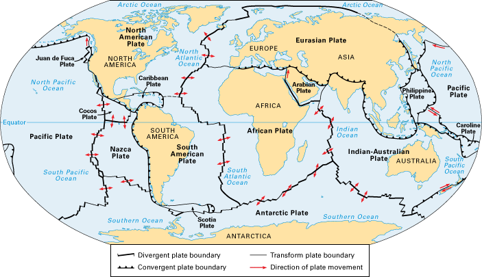
Earth’s rocky outer shell consists of huge slabs called tectonic plates. Many plates include both ocean floor and dry land. The plates slowly move with respect to one another. They spread apart at divergent boundaries, move toward each other at convergent boundaries, and grind past one another at transform boundaries. (World Book map)

The scientists reported that the magnitude 8.6 earthquake opened at least four major seafloor faults (cracks in Earth’s surface) running for several hundred miles (kilometers) in only 2 minutes and 40 seconds. The sides of these faults slipped between 20 to 120 feet (6 to 37 meters) past each other. In some cases, the earthquake turned corners, creating a bizarre gridlike pattern of cracks in the seafloor. The scientists also discovered that a highly unusual number of aftershocks of magnitude 5 or above occurred in the six days following the quakes. Some were felt as far away as the western coast of North America.

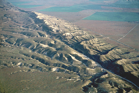
Information from a global network of seismographs had told scientists almost immediately that the magnitude 8.6 quake, which occurred about two hours before the 8.2 quake, was the most powerful strike-slip quake ever recorded. During a strike-slip earthquake, blocks of rock slide past each other horizontally. The Sumatra temblors were also highly unusual because they occurred in the middle of a plate. Strike-slip quakes generally occur at the boundary between two plates, such as along the San Andreas Fault in California.

The San Andreas Fault, like the newly created faults in the Indian Ocean, is a strike-slip fault, a surface fracture where two blocks of rock are sliding past one another horizontally. (© Craig Aurness, Corbis)

The Indian-Australian Plate is breaking up because of tensions between its eastern and western sections. The eastern section, which includes India, is being thrust under the Eurasian Plate to the north. This action, which began tens of millions of years ago, pushed up the Himalaya. Meanwhile, the plate’s western section, which includes Australia, has continued to move to the northeast. From time to time, the tensions cause parts of the plate to suddenly slip past one another.

Two previous earthquakes in the area–a 2004 quake that produced a devastating tsunami in the Indian Ocean and another in 2005–probably put additional stress on the area of the plate that ruptured in April, the scientists reported. The recent quakes did not produce a tsunami because the sideways motion of a strike-slip quake does not cause the up-and-down movement of ocean water that powers the deadly waves. The scientists noted that the final breakup of the plate will occur only after millions of years and several thousand more earthquakes.

Additional World Book articles:

  • Haitian earthquake of 2010
  • When the Earth Moves (a Special Report)
  • Geology (2005) (a Back in Time article)


Tags: earthquake, geology, indian ocean, plate boundary, plate tectonics, seismograph
Posted in Current Events, Natural Disasters, Science | Comments Off

Second Major Earthquake in Northern Italy in Less Than 10 Days

Wednesday, May 30th, 2012

May 30, 2012

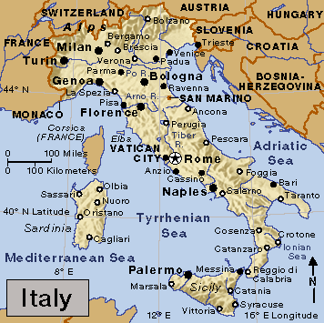
A 5.8-magnitude earthquake on May 29 in the Emilia-Romagna region of northern Italy triggered widespread destruction, killing at least 17 people. The epicenter of the quake, which struck at a depth 6 miles (9.6 kilometers), was 25 miles (40 kilometers) northwest of Bologna. Both the cities of Bologna and Milan were shaken. The quake and dozens of aftershocks came less than 10 days after a 6.0-magnitude earthquake devastated the region, leaving 7 people dead and at least 6,000 homeless. The first earthquake is believed to have weakened many structures, causing the widespread collapse of buildings during the second quake. An estimated 14,000 people are now homeless in the region.

(World Book map; map data © MapQuest.com, Inc.)

The earthquake on May 20–the strongest in this region of Italy for hundreds of years–toppled numerous factories and apartment buildings. Preliminary reports also indicate that the temblor caused significant damage to the region’s cultural heritage, destroying churches, historic buildings, and monuments. The epicenter of the first quake was a small town between Modena and Ferrara. That quake occurred only 3 miles (5 kilometers) below the surface, a surprisingly shallow depth considering its distance–470 miles (750 kilometers)–from the tectonic boundary where the African Plate is pushing into the Eurasian Plate. In general, quakes strike deeper below the surface the farther they are from a plate boundary.

Recent earthquakes in Emilia-Romagna have been linked to the collision of the African Tectonic Plate with the Eurasian Plate.  (World Book map)

Emilia-Romagna is one of Italy’s most productive agricultural regions. Residents report that the two earthquakes have dealt severe blows to the region’s world-famous balsamic vinegar and Parmesan cheese industries.

Additional World Book articles:

  • Plate techtonics
  • When the Earth Moves (a special report)
  • Italy 1997 (a Back in Time article)
  • Italy 2009 (a Back in Time article)


Tags: african plate, earthquake, emilia-romagna, eurasian plate, tectonic plates
Posted in Business & Industry, Current Events, Environment, Science | Comments Off

Newer Entries »
  • Most Popular Tags

    african americans ancient greece archaeology art australia barack obama baseball bashar al-assad basketball black history month china climate change conservation earthquake european union football france global warming iraq isis japan language monday literature major league baseball mars mexico monster monday mythic monday mythology nasa new york city nobel prize presidential election russia space space exploration syria syrian civil war Terrorism ukraine united kingdom united states vladimir putin women's history month world war ii