Monster Storm Brewing Across Eastern U.S.
October 28, 2012
Hurricane Sandy continues to sweep northward through the Atlantic Ocean en route to what forecasters agree will be a devastating landfall along the New Jersey coast, possibly within 100 miles (160 kilometers) of New York City. According to the National Hurricane Center, the huge storm, which is 1,000 miles (1,610 kilometers) wide, is currently producing sustained winds of 85 miles (137 kilometers) per hour and is moving north by northwest at approximately 20 miles (32 kilometers) per hour.
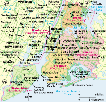
The Hurricane Center issued a warning yesterday that Sandy is likely to create a “life-threatening storm surge” that could cause record-breaking coastal flooding from Delaware to southern New England. In response, authorities across the region ordered the evacuation of low-lying areas. Hurricane Center forecasters predicted that the storm surge could be as much as 11 feet (3.35 meters) above normal tide levels along New York Bay and Long Island Sound. New York Governor Andrew Cuomo ordered the shutdown of subway, bus, and railroad services, and New York City Mayor Bloomberg ordered residents in low-lying areas to evacuate. The mayor also ordered the city schools closed.

Storm surges from Hurricane Sandy were expected to hit the bays south of New York City as well as Long Island Sound northeast of the city. (World Book map)
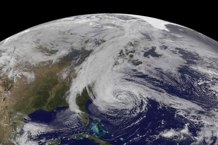
As Hurricane Sandy approaches land, it will collide with a severe winter storm that is moving across the country from the west. At the same time, forecasters expect a burst of arctic air to sweep down through the Canadian Plains. The confluence of these weather systems is expected to wreck havoc from the East Coast to the Great Lakes, even producing massive blizzards as far west as Ohio and Kentucky.
Forecasters believe the storm is on a scale with little precedent along the East Coast. “One of the biggest storms of our lifetimes is unfolding right now,” predicted meteorologist Kelly Cass on The Weather Channel during the cable network’s fourth day of nonstop storm coverage. Public utility officials estimate that as many as 10 million people living along the Philadelphia-New York-Boston corridor are likely to lose electric power as Hurricane Sandy topples trees and light poles, pulling down power lines. The region has not faced a storm this destructive since the New England hurricane of 1938, which left some 600 people dead.

A satellite image taken on Monday, October 28, shows Hurricane Sandy (circular storm) meeting a winter storm (north to south line) covering the Appalachian Mountains. (NASA Earth Observatory image by Robert Simmon with data courtesy of the NASA/NOAA GOES Project Science team.)
Additional World Book articles:
- National Weather Service
- Weather (1938) (a Back in Time article)
- The Forecast: Better Weather Prediction Ahead (a special report)
- How the Ocean Affects Climate (a special report)


