
Harvey’s High Waters
August 30, 2017
Late last Friday night, on August 25, the deluge of Hurricane Harvey began soaking the central coast of Texas in the southern United States. Since then, the storm has continued to dump record rains, causing unprecedented flooding that has displaced some 30,000 people. More than 4 feet (1.2 meters) of rain has saturated the Houston area, submerging low-lying areas and swelling reservoirs to near-breaking points. As Harvey hovers and continues to dump torrential rains, the U.S. National Weather Service warns of “catastrophic” and “life threatening” flooding in southeastern Texas and southwestern Louisiana. As of today, 30 people have died in storm-related incidents.
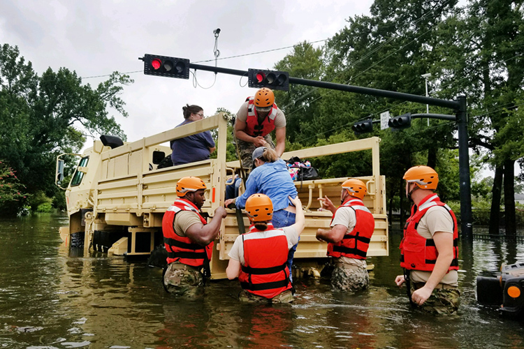
On Aug. 27, 2017, members of the Texas National Guard evacuate Houston residents stranded by Hurricane Harvey’s record flooding. Credit: Lt. Zachary West, Army National Guard
Harvey’s floodwaters have affected 50 counties in Texas, and some 4,000 troops from the Texas National Guard have been deployed—along with thousands of police, firefighters, and other emergency responders—to help the storm’s many victims. Many civilian volunteers are helping, too, using their own boats, food, and other supplies. Numerous people and pets have been rescued by boat, high-water vehicles, and helicopter from automobiles, trees, homes, and rooftops. Hundreds of roads are blocked by high water, and Houston’s airports, schools, and office buildings remain closed. Storm damage is expected to top $20 billion, and repairs and reconstruction after the storm could take years. Some 450,000 people are expected to seek federal disaster assistance. Harvey is the strongest storm to hit Texas since Hurricane Carla in 1961.
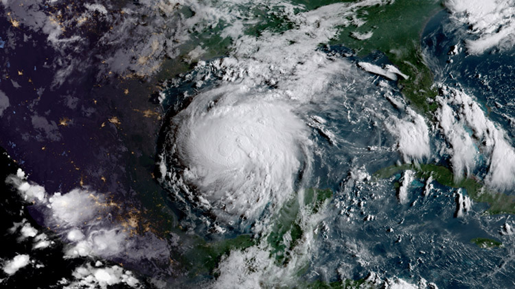
On Aug. 24, 2017, Hurricane Harvey strengthens over the Gulf of Mexico prior to hitting the Texas coast late on August 25. Credit: NOAA/NASA GOES Project
Harvey’s pockets of tornadolike winds have caused some damage, but the storm’s winds—which have lessened enough for Harvey to be downgraded to a tropical storm—have not been the problem. Harvey’s great destructive force has been its rain generation. Very slow moving, Harvey has lingered over the Texas coast and the Gulf of Mexico, turning out multiple thunderstorms from a bottomless water supply. Torrential rains have hit coastal areas for days on end, and flooding and storm surges have not reached their peak potential. The worst may be yet to come before the storm crawls northeast and weakens over land in the coming days.
Harvey formed as a cluster of thunderstorms over the Atlantic Ocean before hitting the island of Barbados as a tropical storm on August 18. The storm fragmented as it crossed Mexico’s Yucatán Peninsula, but it redeveloped and gained strength over the Bay of Campeche. Water temperatures there and in the entire Gulf of Mexico are well above average, and storms like Harvey feed off those warm waters. An expansion of the subtropical high pressure belt gave Harvey a clear and gentle upper atmosphere in which to grow, and the storm coiled and flexed into a hurricane as it neared the Texas coast. The warmer waters and expansion of high pressure areas—as well as a superabundance of moisture in the air—are ripe conditions for hurricane creation. They are also consistent with the effects of anthropogenic (human-caused) climate change. The United Nations World Meteorological Organization linked Harvey’s enormous rainfall with climate change.

