Measuring the 2011 Japanese Earthquake
Dec, 5, 2011
The tsunami that ravaged Japan in March 2011 was powered by earthquake that shifted the seafloor more than 100 times farther than previous quakes in the region. The 9.0-magnitude earthquake was the strongest to hit Japan in more than 130 years. At least 15,800 people died in the resulting tsunami. The disaster also triggered at least one meltdown of a reactor core at a nuclear power plant.
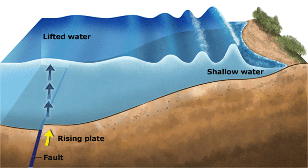
New measurements made off the coast of Honshu, Japan’s main island, have revealed that the quake thrust the seafloor upward by 33 feet (10 meters) and pushed it horizontally 164 feet (50 meters) toward the island. The measurements were made by scientists from the Japan Agency for Marine-Earth Science and Technology using devices that direct sound waves at the seafloor. The returning echoes enabled the scientists to create a map of the area, which they compared with maps made in 1999 and 2004. The violent movement of the seafloor caused the column of water above it to explode upward, setting off waves that traveled outward in all directions. The waves, which built up as they entered shallow water along the coastline, reached heights of at least 30 feet (9 meters). The 2011 quake occured along the border between two of the tectonic plates that make up Earth’s outer shell.

A tsunami can occur when an underwater earthquake displaces a large part of the sea floor. In this illustration, a tsunami wave spreads from a fast-rising section of ocean floor. The rising plate lifts the water above it, raising a hump of water that quickly ripples outward. As the ripple enters shallow water, it slows and grows in height. World Book illustration by Matt Carrington.
Additional World Book articles:


